
Stampa:Uvs Nuur drainage basin.jpg

Daqs tad-dehra proviżorja: 800 × 296 pixels. Riżoluzzjonijiet oħra: 320 × 118 pixels | 640 × 237 pixels | 1,024 × 379 pixels | 1,280 × 473 pixels | 2,794 × 1,033 pixels
Fajl oriġinali (2,794 × 1,033 pixel, dimensjoni: 1.65 MB, tip ta' MIME: image/jpeg)
| Dan huwa fajl mill-Wikimedia Commons. Il-deskrizzjoni fuq il-paġna ta' diskussjoni oriġinali tidher hawn taħt.
|
Taqsira
| Deskrizzjoni |
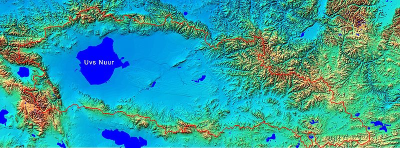
English: Uvs Nuur drainage basin map |
| Data |
21 Frar 2008 (original upload date) |
| Sors | SRTM 90 meters elevation model grid, water bodies from NASA; shaded relief picture and basin area line is my own work |
| Awtur | NASA |
| Permess (Użu mill-ġdid tal-fajl) |
non commercial use |
Liċenzja
| This file is in the public domain in the United States because it was solely created by NASA. NASA copyright policy states that "NASA material is not protected by copyright unless noted". (See Template:PD-USGov, NASA copyright policy page or JPL Image Use Policy.) | ||
 |
Warnings:
|
Original upload log
Transferred from en.wikipedia to Commons by Frokor using CommonsHelper.
The original description page was here. All following user names refer to en.wikipedia.
- 2008-02-21 19:08 Bogomolov.PL 2794×1033×8 (1726167 bytes) better image
- 2008-02-21 19:02 Bogomolov.PL 2794×1033×8 (1067330 bytes) {{Information |Description=Uvs Nuur drainage basin map |Source=SRTM 90 meters elevation model grid, water bodies from NASA; shaded relief picture and basin area line is my own work |Date=21.02.2008 |Location=ftp://e0srp01u.ecs.nasa.gov/srtm/version2/SRTM3
Kronoloġija tal-fajl
Agħfas fuq il-grupp data/ħin biex tara l-fajl biex tara kif jidher dak il-ħin.
| Data/Ħin | Minjatura | Qisien | Utent | Kumment | |
|---|---|---|---|---|---|
| kurrenti | 12:03, 14 Lulju 2008 | 2,794 × 1,033 (1.65 MB) | File Upload Bot (Magnus Manske) | {{BotMoveToCommons|en.wikipedia}} {{Information |Description={{en|Uvs Nuur drainage basin map}} |Source=Transferred from [http://en.wikipedia.org en.wikipedia]; transferred to Commons by User:Frokor using [http://tools.wikimedia.de/~magnus/commonshel |
Użu tal-fajl
Il-Paġna segwenti twassal għal din l-istampa:
L-użu globali tal-fajl
Il-wikis segwenti jużaw dan il-fajl:
- Użu fuq ar.wikipedia.org
- Użu fuq bg.wikipedia.org
- Użu fuq bn.wikipedia.org
- Użu fuq ca.wikipedia.org
- Użu fuq cs.wikipedia.org
- Użu fuq de.wikipedia.org
- Użu fuq en.wikipedia.org
- Użu fuq es.wikipedia.org
- Użu fuq fi.wikipedia.org
- Użu fuq fr.wikipedia.org
- Użu fuq hr.wikipedia.org
- Użu fuq hu.wikipedia.org
- Użu fuq ja.wikipedia.org
- Użu fuq ka.wikipedia.org
- Użu fuq mk.wikipedia.org
- Użu fuq ml.wikipedia.org
- Użu fuq mn.wikipedia.org
- Użu fuq nl.wikipedia.org
- Użu fuq nn.wikipedia.org
- Użu fuq pt.wikipedia.org
- Użu fuq ru.wikipedia.org
- Użu fuq sh.wikipedia.org
- Użu fuq simple.wikipedia.org
- Użu fuq sr.wikipedia.org
- Użu fuq tr.wikipedia.org
- Użu fuq tyv.wikipedia.org
- Użu fuq uk.wikipedia.org
- Użu fuq vi.wikipedia.org
- Użu fuq www.wikidata.org
- Użu fuq zh.wikipedia.org