
Stampa:Netherlands during French administration 1810-1814.png

Daqs tad-dehra proviżorja: 408 × 599 pixels. Riżoluzzjonijiet oħra: 163 × 240 pixels | 520 × 764 pixels
Fajl oriġinali (520 × 764 pixel, dimensjoni: 889 KB, tip ta' MIME: image/png)
| Dan huwa fajl mill-Wikimedia Commons. Il-deskrizzjoni fuq il-paġna ta' diskussjoni oriġinali tidher hawn taħt.
|
Taqsira
| Deskrizzjoni |
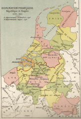
English: Map of Belgium and the Netherlands during the French occupation. Français : Carte de la Belgique et des Pays-Bas pendant l'occupation française. |
||||||||||||||||||||
| Data | before 1910 | ||||||||||||||||||||
| Sors | Scan from Atlas de géographie physique, politique et historique à l'usage de l'enseignement primaire et de l'enseignement moyen, Dessain, Liège, 35e éd., s.d., p. 40. | ||||||||||||||||||||
| Awtur |
|
||||||||||||||||||||

Liċenzja
|
This work is in the public domain in its country of origin and other countries and areas where the copyright term is the author's life plus 100 years or fewer. This work is in the public domain in the United States because it was published (or registered with the U.S. Copyright Office) before January 1, 1929. | |
| This file has been identified as being free of known restrictions under copyright law, including all related and neighboring rights. | |
Kronoloġija tal-fajl
Agħfas fuq il-grupp data/ħin biex tara l-fajl biex tara kif jidher dak il-ħin.
| Data/Ħin | Minjatura | Qisien | Utent | Kumment | |
|---|---|---|---|---|---|
| kurrenti | 11:16, 31 Ottubru 2005 | | 520 × 764 (889 KB) | BrightRaven | Map of Belgium and the Netherlands during the French occupation. Author : MG Alexis |
Użu tal-fajl
Il-2 paġni segwenti jwasslu għal din l-istampa:
L-użu globali tal-fajl
Il-wikis segwenti jużaw dan il-fajl:
- Użu fuq ar.wikipedia.org
- Użu fuq ast.wikipedia.org
- Użu fuq br.wikipedia.org
- Użu fuq ca.wikipedia.org
- Użu fuq cs.wikipedia.org
- Użu fuq en.wikipedia.org
- Użu fuq eo.wikipedia.org
- Użu fuq es.wikipedia.org
- Użu fuq fr.wikipedia.org
- Użu fuq fy.wikipedia.org
- Użu fuq gl.wikipedia.org
- Użu fuq id.wikipedia.org
- Użu fuq it.wikipedia.org
- Użu fuq la.wikipedia.org
- Użu fuq li.wikipedia.org
- Użu fuq nl.wikipedia.org
- Użu fuq vls.wikipedia.org
- Użu fuq zh.wikipedia.org