
Stampa:Keswick Panorama - Oct 2009.jpg

Daqs tad-dehra proviżorja: 800 × 283 pixels. Riżoluzzjonijiet oħra: 320 × 113 pixels | 640 × 226 pixels | 1,024 × 362 pixels | 1,280 × 452 pixels | 2,560 × 905 pixels | 10,814 × 3,822 pixels
Fajl oriġinali (10,814 × 3,822 pixel, dimensjoni: 19.6 MB, tip ta' MIME: image/jpeg)
| Dan huwa fajl mill-Wikimedia Commons. Il-deskrizzjoni fuq il-paġna ta' diskussjoni oriġinali tidher hawn taħt.
|
Taqsira
| Deskrizzjoni |
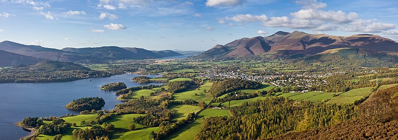
Deutsch: Panorama der Stadt Keswick, England im Lake District vom Walla Crag aus fotografiert. (Panorama aus 2 × 3 Bildern)
English: A 2 × 3 segment panorama of the town of Keswick, nestled between Derwent Water and the fells of Skiddaw in the Lake District, Cumbria, England. Taken from about 3/4 of the way to the summit of Walla Crag.
Français : Vue panoramique sur la ville de Kaswick, nichée entre les chutes de Skiddaw et le lac de Derwent water, depuis les pentes du Walla Crag. Parc national du Lake District, Cumbrie (Royaume-Uni). Panorama obtenu en assemblant six photos organisées en deux rangs.
Italiano: Una panoramica (2x3 foto) del comune mercato di Keswick (Cumbria, Regno Unito) e del territorio circostante. Dominano lo sfondo, i rilievi collinari e montuosi delle Northern Fells (a destra, il gruppo dello Skiddaw): i resti, notevolmente erosi, di un più vasto arco insulare formatosi all'inizio dell'Ordoviciano durante la chiusura dell'Oceano Giapeto (orogenesi caledoniana). La foto è stata scattata nel parco nazionale di Lake District dal monte Walla Crag.
Українська: Панорама Кесвіка, що лежить між озером Деруент і схилами Скіддоу, Озерний край, Англія. Фото зроблено зі схилів Валла-Крегу. |
| Data | |
| Sors | Opra proprja |
| Awtur | Diliff |
| Permess (Użu mill-ġdid tal-fajl) |
Summary:In using this image or any subsequent derivatives of it, you are required to release the image under the same license. As such, any reproduction of this image, in any medium, must appear with a copy of, or full URL of the license.Attribution of this image to the author (DAVID ILIFF) is also required, preferably in a prominent location near the image.No other conditions may be added to, or removed from this license without the permission of the author and copyright holder.Suggested attribution: "Photo by DAVID ILIFF. License: CC BY-SA 3.0"Please review the full license requirements carefully before using this image. If you would like to clarify the terms of the license or negotiate less restrictive commercial licensing outside of the bounds of GFDL/CC-BY-SA, please contact me by email, or if you don't have a Wikipedia account you can either leave a message on my talk page with your contact details and your request, or you can contact me on Facebook. Please also send a 'friend request' to ensure that I am aware of your message. |
| Camera location | | View this and other nearby images on: OpenStreetMap |
|---|
Assessment
Din l-istampa ġiet magħżulha bħala stampa tal-ġurnata għal 7 May 2010. Id-deskrizzjoni tagħha hi: English: The town of Keswick, nestled between the fells of Skiddaw and Derwent Water in the Lake District, Cumbria, England. Bassenthwaite Lake in the background. A 2 × 3 segment panorama taken from about 3/4 of the way to the summit of Walla Crag. Lingwi oħra:
Dansk: Et panorama over byen Keswick i Lake District, Cumbria, England. Taget fra et sted omkring 3/4 af vejen til toppen af Walla Crag. Deutsch: Blick vom Walla Crag auf die Stadt Keswick zwischen dem Skiddaw und Derwent Water in der nordenglischen Grafschaft Cumbria English: The town of Keswick, nestled between the fells of Skiddaw and Derwent Water in the Lake District, Cumbria, England. Bassenthwaite Lake in the background. A 2 × 3 segment panorama taken from about 3/4 of the way to the summit of Walla Crag. Español: La ciudad de Keswick entre las faldas de Skiddaw y Derwent Water en el Distrito de los Lagos, Cumbria, Inglaterra. Al fondo está el Lago Bassenthwaite. Segmento 2 × 3 de una panorámica tomada a unos 3/4 en el camino a la cima del Walla Crag. Italiano: Una panoramica del comune mercato di Keswick (Cumbria, Regno Unito) e del territorio circostante. Dominano lo sfondo, i rilievi collinari e montuosi delle Northern Fells (a destra, il gruppo dello Skiddaw): i resti, notevolmente erosi, di un più vasto arco insulare formatosi all'inizio dell'Ordoviciano durante la chiusura dell'Oceano Giapeto (orogenesi caledoniana) Nederlands: Panorama over het dorp Keswick, dat ligt ingebed tussen de fells (Engels equivalent van fjell) van de berg Skiddaw (931 meter) en het meer Derwent Water in het nationaal park Lake District van het Engelse graafschap Cumbria. Foto genomen vanaf de weg naar de top van de fell Walla Crag. Svenska: Staden Keswick, mellan kullarna i Skiddaw och Derwent Water i Cumbria, England. Bassenthwaite Lake i bakgrunden. Ett 2 × 3 panorama taget från ungefär 3/4 av vägen till toppen av Walla Crag. Русский: Панорамный вид на гору Кесуик, рядом с озером Бассентуэйт в Озёрном крае, Камбрия, Англия. Снято с вершины горы Уолла-Крэг. 한국어: 영국 잉글랜드 컴브리아 주 케즈윅의 파노라마 전경. 스키도 산과 더웬트 강 사이에 자리하고 있다. 日本語: イギリス、カンブリアの湖水地方の眺め。右の山はスキッドー (Skiddaw)、左の湖はダーウェントウォーター (Derwent Water)、間にある町はケズウィック (Keswick) である。撮影:David Iliff |
|

Liċenzja
Jiena, id-detentur tal-copyright ta' dan ix-xogħol, niddikjara li se nippubblikah taħt il-liċenzji segwenti:
Dan il-fajl huwa liċenzjat taħt it-termini tal-liċenzja Creative Commons Attribuzzjoni-Aqsam bl-istess mod 3.0 Unported
- Inti ħieles:
- li taqsam – li tikkopja, tiddistribwixxi u tittrażmetti din l-opra
- li timmodifika – li tadatta l-biċċa xogħol
- Taħt il-kundizzjonijiet segwenti:
- attribuzzjoni – Għandek tattribwixxi x-xogħol bil-mod speċifikat mill-awtur jew minn min ta l-l-iċenzja (imma mhux b'xi mod li jissuġġerixxi ji jappoġjaw lilek jew l-użu tax-xogħol).
- Ixxerja bl-istess mod – Jekk tbiddel, tittrasforma jew tibni fuq dan il-materjal, inti għandek bżonn taqsam il-kontribuzzjonijiet tiegħek taħt l-istess liċenzja jew waħda li taqbel ma' dik oriġinali.

|
Huwa permess li tikkopja, tiddistribwixxi u/jew timmodifika dan id-dokument abbażi tat-termini tal-Liċenzja ta' Dokumentazzjoni Ħielsa tal-GNU, Verżjoni 1.2 jew kwalunkwe verżjoni oħra pubblikata mill-Free Software Foundation; mingħajr ebda sezzjoni non-modifikabbli, mingħajr test tal-faċċata u mingħajr test tal-qoxra. Kopja tal-liċenzja hi inkluża fis-sezzjoni intitolata Test tal-Liċenzja ta' Dokumentazzjoni Ħielsa tal-GNU". |
Tista' tagħżel il-liċenzja li tippreferi.
| Annotations | This image is annotated: View the annotations at Commons |
Kronoloġija tal-fajl
Agħfas fuq il-grupp data/ħin biex tara l-fajl biex tara kif jidher dak il-ħin.
| Data/Ħin | Minjatura | Qisien | Utent | Kumment | |
|---|---|---|---|---|---|
| kurrenti | 21:48, 21 Ottubru 2009 | 10,814 × 3,822 (19.6 MB) | Diliff | {{Information |Description={{en|1=A 2 x 3 segment panorama of the town of Keswick, nestled between the fells of Skiddaw and Derwent Water in the Lake District, Cumbria, England. Taken from about 3/4 of the way to the summit of Walla Crag.}} |Source=Own wo |
Użu tal-fajl
Il-Paġna segwenti twassal għal din l-istampa:
L-użu globali tal-fajl
Il-wikis segwenti jużaw dan il-fajl:
- Użu fuq ar.wikipedia.org
- ماري آننغ
- مارغريت بوندفيلد
- أرتشيبالد سايس
- ألغيرنون تشارلز سوينبورن
- جون أوسبورن
- تيرنس راتيغان
- إيفور نوفيلو
- جون داولاند
- مالكولم مكلارين
- بولا كوكس
- كينيث كلارك
- ليك ديستريكت
- كيث براون
- غافن هاملتون
- فيكتوريا وود
- تيري ووجان
- ميج موندي
- بيتر ماكسويل ديفيز
- دورين ماسي
- اريك لوبوك
- توم كيبل
- روني كوربيت
- دينيس روبرتسون
- إريك براون ميلروز
- كين آدم
- باتريك ماكني
- رون مودي
- جون براكستون هيكس
- أنتوني كارو
- بياتريس دي كاردي
- صموئيل بتلر
- إيان ماك إيوان
- مايكل غوف
- جيمس ريتشلردسون
- أندرو لانغ
- سيموندز بوسي
- جوليان ريتشينجس
- ديكستر فليتشر
- جوناثان هايد
- روث رندل
- هنري بريدهام ويبل
- مايج سايرس
- تشارلز روبرت
- نيستا هيلين وبستر
- وليام بن
- إدوارد مارشال هول
- هدسون تايلور
- أليس بيلي
- مارك ميلر
- إدوين أرنولد
Ara l-użu globali ta' dan il-fajl.