
Stampa:Karte Haus Burgund 4 EN.png
Daqs tad-dehra proviżorja: 426 × 600 pixels. Riżoluzzjonijiet oħra: 170 × 240 pixels | 341 × 480 pixels | 545 × 768 pixels | 727 × 1,024 pixels | 2,500 × 3,521 pixels
Fajl oriġinali (2,500 × 3,521 pixel, dimensjoni: 1.33 MB, tip ta' MIME: image/png)
| Dan huwa fajl mill-Wikimedia Commons. Il-deskrizzjoni fuq il-paġna ta' diskussjoni oriġinali tidher hawn taħt.
|
| Deskrizzjoni |
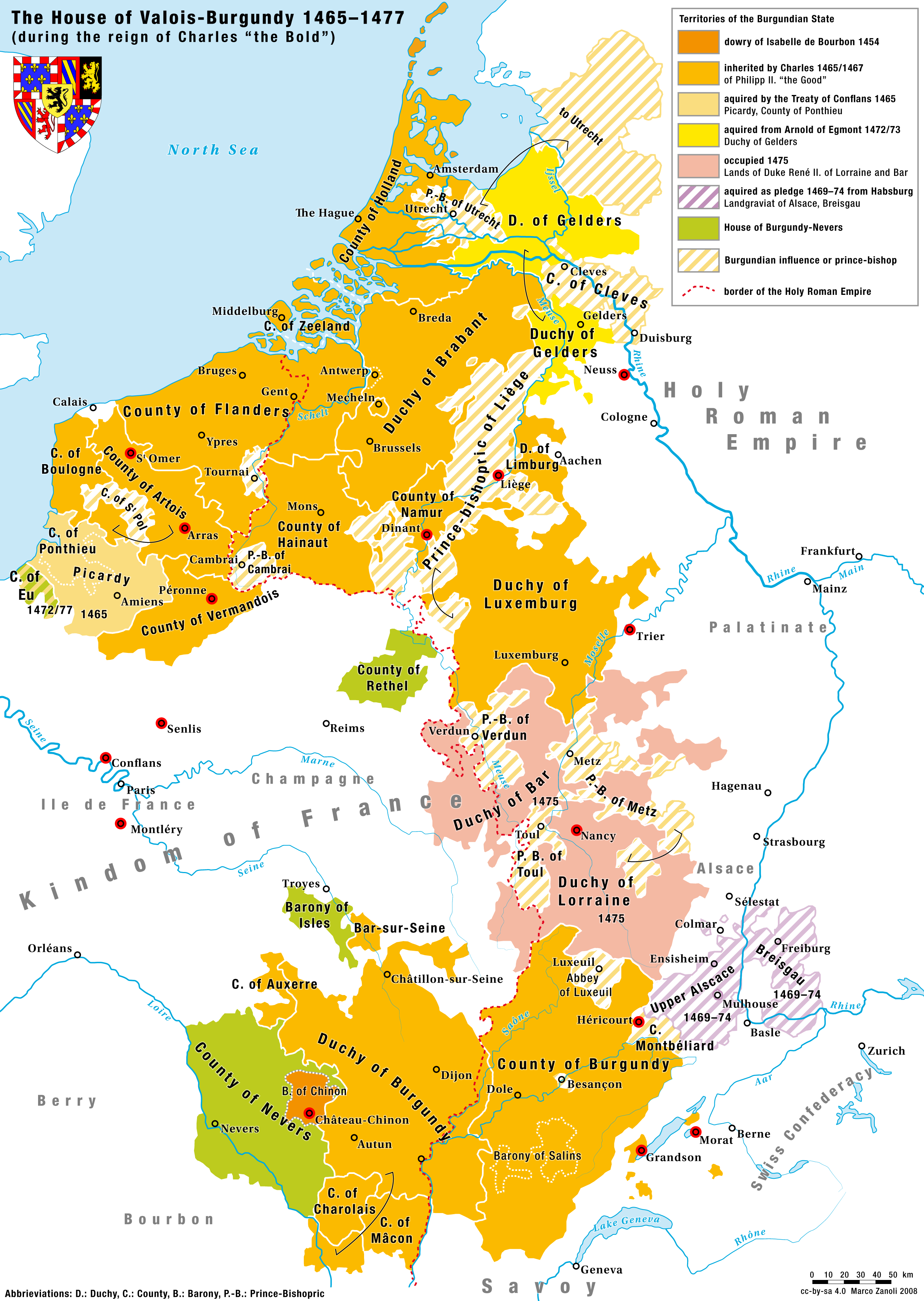
English: Territories of the House of Valois-Burgundy during the reign of Charles the Bold, 1465/67–1477 |
|
| Data | 2.5.2008 | |
| Sors | Opra proprja | |
| Awtur | Marco Zanoli (sidonius 12:09, 2 May 2008 (UTC)) | |
| Permess (Użu mill-ġdid tal-fajl) |
|
|
| Verżjonijiet oħra |
Coat of arms from: 
|


-ka.svg)

Kronoloġija tal-fajl
Agħfas fuq il-grupp data/ħin biex tara l-fajl biex tara kif jidher dak il-ħin.
| Data/Ħin | Minjatura | Qisien | Utent | Kumment | |
|---|---|---|---|---|---|
| kurrenti | 16:10, 24 Awwissu 2023 | | 2,500 × 3,521 (1.33 MB) | Sidonius | corrected some mistakes and adapted to layout and design of German and French Version |
| 04:52, 4 Lulju 2010 |  | 1,200 × 1,690 (652 KB) | DcoetzeeBot | Remove watermark, add author and license data to image metadata, decrease filesize with pngcrush | |
| 14:04, 17 Ġunju 2008 |  | 1,200 × 1,690 (798 KB) | Sidonius | small corrections, important cities and battles marked with red dot, county of cleves added etc. | |
| 12:09, 2 Mejju 2008 |  | 1,200 × 1,787 (529 KB) | Sidonius | {{Information |Description={{en|Territories of the House of Valois-Burgundy during the reign of Charles the Bold, 1465/67–1477}} |Source=own work |Date=2.5.2008 |Author=Marco Zanoli (~~~~) |Permission={{Attribution sidonius}} |other_versions=Coat of arm |
Użu tal-fajl
Il-3 paġni segwenti jwasslu għal din l-istampa:
L-użu globali tal-fajl
Il-wikis segwenti jużaw dan il-fajl:
- Użu fuq ar.wikipedia.org
- Użu fuq ast.wikipedia.org
- Użu fuq azb.wikipedia.org
- Użu fuq az.wikipedia.org
- Użu fuq be.wikipedia.org
- Użu fuq bg.wikipedia.org
- Użu fuq ca.wikipedia.org
- Użu fuq cs.wikipedia.org
- Użu fuq de.wikipedia.org
- Użu fuq el.wikipedia.org
- Użu fuq en.wikipedia.org
- Użu fuq eo.wikipedia.org
- Użu fuq es.wikipedia.org
- Użu fuq et.wikipedia.org
- Użu fuq eu.wikipedia.org
- Użu fuq fa.wikipedia.org
- Użu fuq fi.wikipedia.org
- Użu fuq fr.wikipedia.org
- Użu fuq ga.wikipedia.org
- Użu fuq gl.wikipedia.org
- Użu fuq he.wikipedia.org
- Użu fuq hr.wikipedia.org
Ara l-użu globali ta' dan il-fajl.