
Stampa:Ukrania quae et Terra Cosaccorum cum vicinis Walachiae, Moldoviae, Johann Baptiste Homann (Nuremberg, 1720).jpg

Fajl oriġinali (7,000 × 5,793 pixel, dimensjoni: 5.32 MB, tip ta' MIME: image/jpeg)
| Dan huwa fajl mill-Wikimedia Commons. Il-deskrizzjoni fuq il-paġna ta' diskussjoni oriġinali tidher hawn taħt.
|
Taqsira
| Deskrizzjoni |
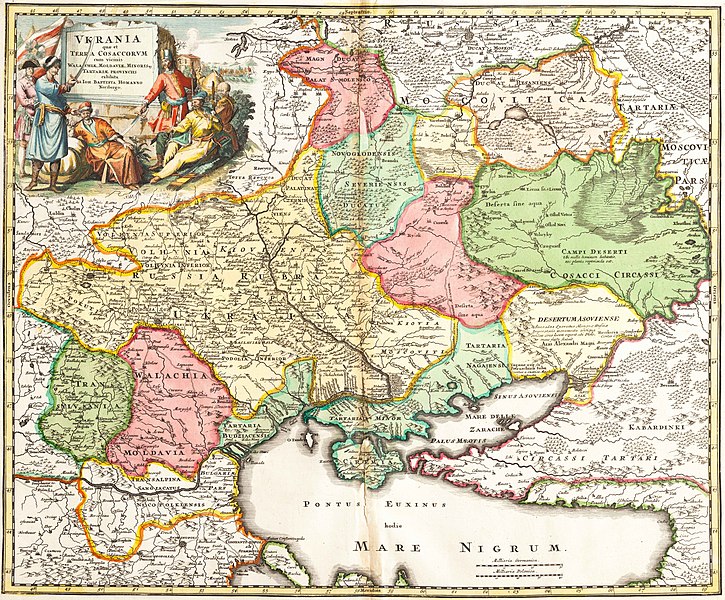
Українська: Ukrania quae et Terra Cosaccorum cum vicinis Walachiae, Moldoviae, Johann Baptiste Homann (Nuremberg, 1720) «Україна або козацька земля з прилеглими провінціями Валахії, Молдавії і Малої Татарії, зображена Йоганом-Баптистом Гоманном». |
|||||||||||||||||||||||
| Data | ||||||||||||||||||||||||
| Sors | Vkraina | |||||||||||||||||||||||
| Awtur |
|
|||||||||||||||||||||||
.jpg)
.jpg)
Liċenzja
|
This work is in the public domain in its country of origin and other countries and areas where the copyright term is the author's life plus 100 years or fewer. | |
| This file has been identified as being free of known restrictions under copyright law, including all related and neighboring rights. | |
Kronoloġija tal-fajl
Agħfas fuq il-grupp data/ħin biex tara l-fajl biex tara kif jidher dak il-ħin.
| Data/Ħin | Minjatura | Qisien | Utent | Kumment | |
|---|---|---|---|---|---|
| kurrenti | 21:12, 20 Settembru 2021 | | 7,000 × 5,793 (5.32 MB) | Lanamy | Higher resolution |
| 15:00, 28 Mejju 2014 |  | 2,500 × 2,069 (3.29 MB) | VLebid | User created page with UploadWizard |
Użu tal-fajl
Il-Paġna segwenti twassal għal din l-istampa:
L-użu globali tal-fajl
Il-wikis segwenti jużaw dan il-fajl:
- Użu fuq ar.wikipedia.org
- Użu fuq be-tarask.wikipedia.org
- Użu fuq bg.wikipedia.org
- Użu fuq ca.wikipedia.org
- República Socialista Soviètica d'Ucraïna
- Accident de Txornòbil
- Galítsia
- Bucovina
- Kanat de Crimea
- Front Oriental de la Segona Guerra Mundial
- Cosacs
- Imperi Rus
- Holodomor
- Rada Suprema
- Confederació de Polònia i Lituània
- Bandera d'Ucraïna
- Revolució Taronja
- Ucraïnesos
- President d'Ucraïna
- Gran Ducat de Lituània
- Llista de museus d'Ucraïna
- Literatura d'Ucraïna
- Petita Rússia
- Nova Rússia
- Rus de Kíev
- Invasió mongola de la Rus de Kíev
- Crisi del gas entre Ucraïna i Rússia
- Hetmanat cosac
- Principat de Galítsia-Volínia
- República Popular d'Ucraïna
- Història d'Ucraïna
- Tractat de Pereiàslav
- República Popular d'Ucraïna Occidental
- Directori d'Ucraïna
- Eslaus orientals
- Estat Ucraïnès
- Rus (poble)
- Zaporoges
- Organització dels nacionalistes ucraïnesos
- Marge dret d'Ucraïna
- Marge esquerre d'Ucraïna
- Euromaidan
- Relacions entre Ucraïna i la Unió Europea
- Constitució d'Ucraïna
- Crisi de Crimea
- Nacionalisme ucraïnès
- Massacre de polonesos a Volínia
- Rebel·lió de Khmelnitski
- Guerra al Donbàs
- Ucraïna Slobodà
- Consell de Ministres d'Ucraïna
Ara l-użu globali ta' dan il-fajl.
.jpg)
.jpg)