
Stampa:Orontid Armenia -250-en.svg

Size of this PNG preview of this SVG file: 800 × 470 pixels. Riżoluzzjonijiet oħra: 320 × 188 pixels | 640 × 376 pixels | 1,024 × 601 pixels | 1,280 × 751 pixels | 2,560 × 1,503 pixels | 2,717 × 1,595 pixels
Fajl oriġinali (Fajl fil-format SVG, dimensjoni nominali 2,717 × 1,595 pixel, dimensjoni tal-fajl: 766 KB)
| Dan huwa fajl mill-Wikimedia Commons. Il-deskrizzjoni fuq il-paġna ta' diskussjoni oriġinali tidher hawn taħt.
|
Taqsira
| Deskrizzjoni |
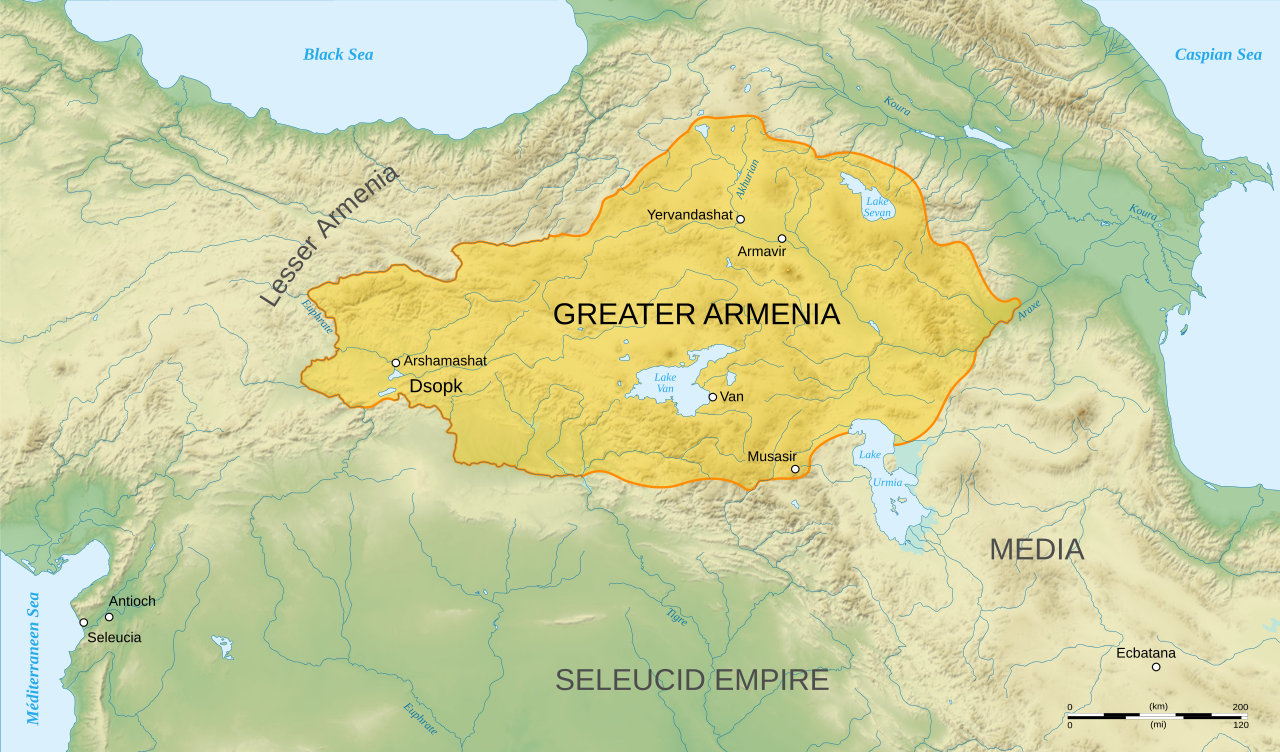
English: Map of Orontid Armenia, around the year 250 BCE.
Français : Carte en anglais de l'Arménie sous la dynastie orontide, vers l'an -250. |
||
| Data | |||
| Sors |
Own work.
Sources :
Software used :
Autres données :
|
||
| Awtur | Sémhur | ||
| Verżjonijiet oħra |
[]
| ||
| Attribuzzjoni (required by the license) | © Sémhur / Wikimedia Commons / | ||
| SVG | W3C-validity not checked.
|
||
| Atelier graphique |


| Camera location | | View this and other nearby images on: OpenStreetMap |
|---|
Liċenzja
Jiena, id-detentur tal-copyright ta' dan ix-xogħol, niddikjara li se nippubblikah taħt il-liċenzji segwenti:
| Copyleft: This work of art is free; you can redistribute it and/or modify it according to terms of the Free Art License. You will find a specimen of this license on the Copyleft Attitude site as well as on other sites. |
This file is licensed under the Creative Commons Attribution-Share Alike 4.0 International, 3.0 Unported, 2.5 Generic, 2.0 Generic and 1.0 Generic license.
- Inti ħieles:
- li taqsam – li tikkopja, tiddistribwixxi u tittrażmetti din l-opra
- li timmodifika – li tadatta l-biċċa xogħol
- Taħt il-kundizzjonijiet segwenti:
- attribuzzjoni – Għandek tattribwixxi x-xogħol bil-mod speċifikat mill-awtur jew minn min ta l-l-iċenzja (imma mhux b'xi mod li jissuġġerixxi ji jappoġjaw lilek jew l-użu tax-xogħol).
- Ixxerja bl-istess mod – Jekk tbiddel, tittrasforma jew tibni fuq dan il-materjal, inti għandek bżonn taqsam il-kontribuzzjonijiet tiegħek taħt l-istess liċenzja jew waħda li taqbel ma' dik oriġinali.
Tista' tagħżel il-liċenzja li tippreferi.
Kronoloġija tal-fajl
Agħfas fuq il-grupp data/ħin biex tara l-fajl biex tara kif jidher dak il-ħin.
| Data/Ħin | Minjatura | Qisien | Utent | Kumment | |
|---|---|---|---|---|---|
| kurrenti | 18:47, 12 Jannar 2008 | | 2,717 × 1,595 (766 KB) | Sémhur | == Description == {{Information |Description= {{en| Map of Orontid Armenia, around the year -250 AD.}} {{fr| Carte en anglais de l'Arménie sous la dynastie orontide, vers l'an -250.}} |Source=Own work. { |
Użu tal-fajl
Il-Paġna segwenti twassal għal din l-istampa:
L-użu globali tal-fajl
Il-wikis segwenti jużaw dan il-fajl:
- Użu fuq ar.wikipedia.org
- Użu fuq avk.wikipedia.org
- Użu fuq azb.wikipedia.org
- Użu fuq en.wikipedia.org
- Użu fuq fa.wikipedia.org
- Użu fuq hy.wikipedia.org
- Տիգրան Մեծ
- Հայեր
- Տրդատ Գ
- Արտաշեսյաններ
- Երվանդունիներ
- Արշակունիներ
- Վաղարշակ Ա
- Ռուբեն Ա
- Արտավազդ Ա
- Արտավազդ Գ
- Արտավազդ Դ
- Արտավազդ Ե
- Արտավազդ Բ
- Արտաշես Ա Բարեպաշտ
- Արտաշես Դ
- Վռամշապուհ
- Արտաշես Բ
- Արշակ Ա
- Արշակ Գ
- Արշակ Բ
- Պապ թագավոր
- Աշոտ Ա Մեծ
- Աշոտ Գ Ողորմած
- Աշոտ Դ Քաջ
- Գագիկ Բ
- Հովհաննես-Սմբատ
- Հեթում Ա
- Ֆիլիպ (Կիլիկիայի թագավոր)
- Հեթում Բ
- Հեթումյաններ
- Օշին Ա
- Տրդատ Բ
- Տրդատ Ա
- Խոսրով Ա
- Վաղարշ Ա
- Սոհեմոս
Ara l-użu globali ta' dan il-fajl.