
Stampa:Map of East and West Florida in 1819.jpg

Mhux disponibli verżjonijiet b'risoluzzjoni akbar.
Map_of_East_and_West_Florida_in_1819.jpg (632 × 420 pixel, dimensjoni: 148 KB, tip ta' MIME: image/jpeg)
| Dan huwa fajl mill-Wikimedia Commons. Il-deskrizzjoni fuq il-paġna ta' diskussjoni oriġinali tidher hawn taħt.
|
Taqsira
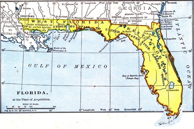
| Deskrizzjoni |
English: The British had divided Florida into the administrative units of East Florida and West Florida during their ownership (1763–1783). |
| Data | |
| Sors |
Project Gutenberg http://www.gutenberg.org/files/35558/35558-h/images/2.jpg |
| Awtur | Mhux magħruf |
Liċenzja
This work is in the public domain in the United States because it was published (or registered with the U.S. Copyright Office) before January 1, 1929.
Public domain works must be out of copyright in both the United States and in the source country of the work in order to be hosted on the Commons. If the work is not a U.S. work, the file must have an additional copyright tag indicating the copyright status in the source country.
Note: This tag should not be used for sound recordings. |
Kronoloġija tal-fajl
Agħfas fuq il-grupp data/ħin biex tara l-fajl biex tara kif jidher dak il-ħin.
| Data/Ħin | Minjatura | Qisien | Utent | Kumment | |
|---|---|---|---|---|---|
| kurrenti | 18:09, 16 Lulju 2019 | | 632 × 420 (148 KB) | Carlstak | User created page with UploadWizard |
Użu tal-fajl
Il-Paġna segwenti twassal għal din l-istampa:
L-użu globali tal-fajl
Il-wikis segwenti jużaw dan il-fajl:
- Użu fuq en.wikipedia.org
- Użu fuq he.wikipedia.org