
Stampa:Map Crusader states 1190-en.svg

Size of this PNG preview of this SVG file: 441 × 600 pixels. Riżoluzzjonijiet oħra: 176 × 240 pixels | 353 × 480 pixels | 565 × 768 pixels | 753 × 1,024 pixels | 1,506 × 2,048 pixels | 978 × 1,330 pixels
Fajl oriġinali (Fajl fil-format SVG, dimensjoni nominali 978 × 1,330 pixel, dimensjoni tal-fajl: 470 KB)
| Dan huwa fajl mill-Wikimedia Commons. Il-deskrizzjoni fuq il-paġna ta' diskussjoni oriġinali tidher hawn taħt.
|
Taqsira
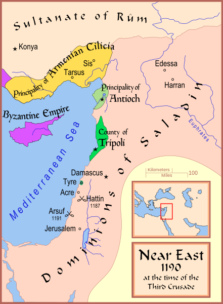
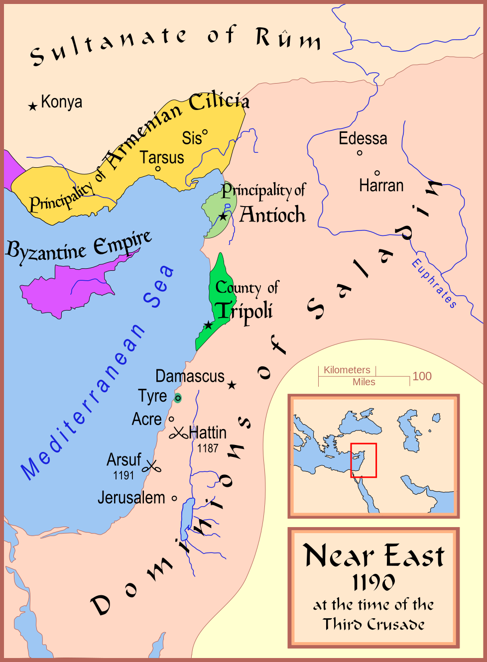
| Deskrizzjoni | A map showing the Near East (the Levant) in 1190. |
| Data | |
| Sors | Opra proprja |
| Awtur | MapMaster |
| Verżjonijiet oħra |
[]
See also |


References
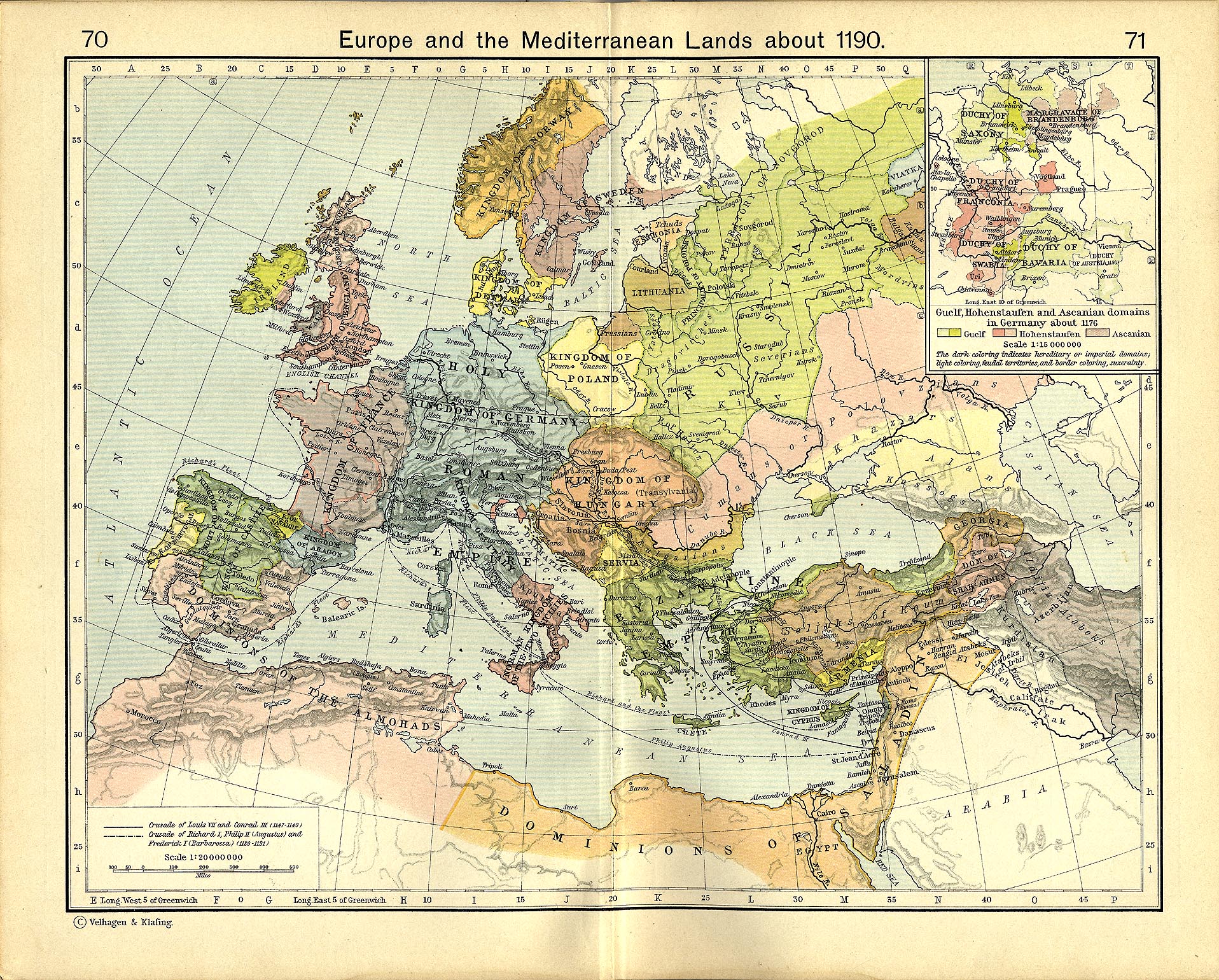
- Shepherd, William R. (1911) "Europe and the Mediterranean Lands about 1190"
Liċenzja
Jiena, id-detentur tal-copyright ta' dan ix-xogħol, niddikjara li se nippubblikah taħt il-liċenzji segwenti:

|
Huwa permess li tikkopja, tiddistribwixxi u/jew timmodifika dan id-dokument abbażi tat-termini tal-Liċenzja ta' Dokumentazzjoni Ħielsa tal-GNU, Verżjoni 1.2 jew kwalunkwe verżjoni oħra pubblikata mill-Free Software Foundation; mingħajr ebda sezzjoni non-modifikabbli, mingħajr test tal-faċċata u mingħajr test tal-qoxra. Kopja tal-liċenzja hi inkluża fis-sezzjoni intitolata Test tal-Liċenzja ta' Dokumentazzjoni Ħielsa tal-GNU". |
This file is licensed under the Creative Commons Attribution-Share Alike 4.0 International, 3.0 Unported, 2.5 Generic, 2.0 Generic and 1.0 Generic license.
- Inti ħieles:
- li taqsam – li tikkopja, tiddistribwixxi u tittrażmetti din l-opra
- li timmodifika – li tadatta l-biċċa xogħol
- Taħt il-kundizzjonijiet segwenti:
- attribuzzjoni – Għandek tattribwixxi x-xogħol bil-mod speċifikat mill-awtur jew minn min ta l-l-iċenzja (imma mhux b'xi mod li jissuġġerixxi ji jappoġjaw lilek jew l-użu tax-xogħol).
- Ixxerja bl-istess mod – Jekk tbiddel, tittrasforma jew tibni fuq dan il-materjal, inti għandek bżonn taqsam il-kontribuzzjonijiet tiegħek taħt l-istess liċenzja jew waħda li taqbel ma' dik oriġinali.
Tista' tagħżel il-liċenzja li tippreferi.
Kronoloġija tal-fajl
Agħfas fuq il-grupp data/ħin biex tara l-fajl biex tara kif jidher dak il-ħin.
| Data/Ħin | Minjatura | Qisien | Utent | Kumment | |
|---|---|---|---|---|---|
| kurrenti | 17:35, 13 Frar 2008 | | 978 × 1,330 (470 KB) | MapMaster | Slight changes |
| 17:28, 13 Frar 2008 |  | 978 × 1,330 (464 KB) | MapMaster | {{Information |Description=A map showing the Near East (the Levant) in 1190. |Source=self-made |Date=12 Feb 2008 |Author= MapMaster |Permission= |other_versions=see below }} ==Other versions== *[[:Image:Die Levante 1135 |
Użu tal-fajl
Il-Paġna segwenti twassal għal din l-istampa:
L-użu globali tal-fajl
Il-wikis segwenti jużaw dan il-fajl:
- Użu fuq arz.wikipedia.org
- Użu fuq azb.wikipedia.org
- Użu fuq az.wikipedia.org
- Użu fuq be.wikipedia.org
- Użu fuq bg.wikipedia.org
- Użu fuq br.wikipedia.org
- Użu fuq ckb.wikipedia.org
- Użu fuq da.wikipedia.org
- Użu fuq de.wikipedia.org
- Użu fuq el.wikipedia.org
- Użu fuq en.wikipedia.org
- Kingdom of Jerusalem
- Richard I of England
- 1190
- Third Crusade
- Guy of Lusignan
- Battle of Arsuf
- Conrad of Montferrat
- Crusader states
- Krak des Chevaliers
- Siege of Acre (1189–1191)
- Bohemond III of Antioch
- Bohemond IV of Antioch
- Talk:Battle of Hattin
- Crusades
- Timeline of the Kingdom of Jerusalem
- Timeline of the Principality of Antioch
- User:Falcaorib
- Fall of Outremer
- Użu fuq et.wikipedia.org
- Użu fuq fi.wikipedia.org
- Użu fuq he.wikipedia.org
- Użu fuq hr.wikipedia.org
- Użu fuq hu.wikipedia.org
- Użu fuq hy.wikipedia.org
Ara l-użu globali ta' dan il-fajl.