
Stampa:Kotzebue Alaska aerial view.jpg

Daqs tad-dehra proviżorja: 800 × 600 pixels. Riżoluzzjonijiet oħra: 320 × 240 pixels | 640 × 480 pixels | 1,024 × 768 pixels | 1,280 × 960 pixels | 1,500 × 1,125 pixels
Fajl oriġinali (1,500 × 1,125 pixel, dimensjoni: 372 KB, tip ta' MIME: image/jpeg)
| Dan huwa fajl mill-Wikimedia Commons. Il-deskrizzjoni fuq il-paġna ta' diskussjoni oriġinali tidher hawn taħt.
|
| Deskrizzjoni |
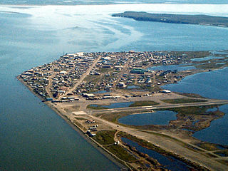
English: Aerial view of Kotzebue, Alaska, U.S. |
|||
| Location | Kotzebue, Alaska, U.S. 66°53′49.97″N 162°35′8.3″W / 66.8972139°N 162.585639°W |
|||
| Data | ||||
| Sors |
U.S. Army Corps of Engineers Digital Visual Library Image page Image description page Digital Visual Library home page |
|||
| Awtur | U.S. Army Corps of Engineers, photographer not specified or unknown | |||
| Permess (Użu mill-ġdid tal-fajl) |
|
Kronoloġija tal-fajl
Agħfas fuq il-grupp data/ħin biex tara l-fajl biex tara kif jidher dak il-ħin.
| Data/Ħin | Minjatura | Qisien | Utent | Kumment | |
|---|---|---|---|---|---|
| kurrenti | 03:42, 21 Marzu 2007 | | 1,500 × 1,125 (372 KB) | DanMS | {{Information | Description = {{en|Aerial view of Kotzebue, Alaska, USA.}} | Source = U.S. Army Corps of Engineers Digital Visual Library<br />[http://images.usace.army.mil/images/Hires/cepoa170.jpg Image page]<br />[http://images.usace.army.mi |
Użu tal-fajl
Il-Paġna segwenti twassal għal din l-istampa:
L-użu globali tal-fajl
Il-wikis segwenti jużaw dan il-fajl:
- Użu fuq ar.wikipedia.org
- Użu fuq azb.wikipedia.org
- Użu fuq az.wikipedia.org
- Użu fuq bg.wikipedia.org
- Użu fuq ca.wikipedia.org
- Użu fuq ceb.wikipedia.org
- Użu fuq ch.wikipedia.org
- Użu fuq de.wikipedia.org
- Użu fuq es.wikipedia.org
- Użu fuq fa.wikipedia.org
- Użu fuq fi.wikipedia.org
- Użu fuq fr.wikipedia.org
- Użu fuq fr.wikivoyage.org
- Użu fuq he.wikipedia.org
- Użu fuq ik.wikipedia.org
- Użu fuq it.wikipedia.org
- Użu fuq ko.wikipedia.org
- Użu fuq mg.wikipedia.org
- Użu fuq ml.wikipedia.org
- Użu fuq mrj.wikipedia.org
- Użu fuq nl.wikipedia.org
- Użu fuq nn.wikipedia.org
- Użu fuq no.wikipedia.org
- Użu fuq pl.wikipedia.org
- Użu fuq pt.wikipedia.org
- Użu fuq ru.wikipedia.org
- Użu fuq sh.wikipedia.org
- Użu fuq simple.wikipedia.org
- Użu fuq sr.wikipedia.org
- Użu fuq sv.wikipedia.org
- Użu fuq szl.wikipedia.org
- Użu fuq tly.wikipedia.org
- Użu fuq tr.wikipedia.org
- Użu fuq uk.wikipedia.org
- Użu fuq ur.wikipedia.org
- Użu fuq uz.wikipedia.org
- Użu fuq www.wikidata.org
- Użu fuq zh-min-nan.wikipedia.org