
Stampa:Kingdom of Arles 1000.svg

Size of this PNG preview of this SVG file: 485 × 340 pixels. Riżoluzzjonijiet oħra: 320 × 224 pixels | 640 × 449 pixels | 1,024 × 718 pixels | 1,280 × 897 pixels | 2,560 × 1,795 pixels
Fajl oriġinali (Fajl fil-format SVG, dimensjoni nominali 485 × 340 pixel, dimensjoni tal-fajl: 1.25 MB)
| Dan huwa fajl mill-Wikimedia Commons. Il-deskrizzjoni fuq il-paġna ta' diskussjoni oriġinali tidher hawn taħt.
|
Taqsira
This vector image was created with Inkscape .


.svg)
.svg)
.svg)
.svg)
.svg)


.svg)
.svg)
.svg)


.png)
.png)


.svg)


.svg)

.svg)


.svg)
.svg)
.svg)
.svg)


.svg)
.png)


.svg)


.svg)
.svg)


.svg)


.svg)


.svg)
.svg)
.svg)
.svg)
.svg)
.svg)
.svg)
.svg)
_cropped.svg)
.svg)
.svg)
.svg)
.svg)
.svg)
.svg)
.svg)
.svg)
.svg)
.svg)
.svg)
.svg)
.svg)
.svg)
.svg)
.svg)
.svg)
.svg)
.svg)
.svg)
.svg)
.svg)
.svg)
.svg)
.svg)
.svg)
.svg)
.svg)
.svg)
.svg)
.svg)
.svg)
.svg)
.svg)
.svg)
.svg)
.svg)
.svg)
.svg)
.svg)
.svg)
.svg)
.svg)
.svg)
.svg)
Liċenzja
This file is licensed under the Creative Commons Attribution-Share Alike 4.0 International license.
- Inti ħieles:
- li taqsam – li tikkopja, tiddistribwixxi u tittrażmetti din l-opra
- li timmodifika – li tadatta l-biċċa xogħol
- Taħt il-kundizzjonijiet segwenti:
- attribuzzjoni – Għandek tattribwixxi x-xogħol bil-mod speċifikat mill-awtur jew minn min ta l-l-iċenzja (imma mhux b'xi mod li jissuġġerixxi ji jappoġjaw lilek jew l-użu tax-xogħol).
- Ixxerja bl-istess mod – Jekk tbiddel, tittrasforma jew tibni fuq dan il-materjal, inti għandek bżonn taqsam il-kontribuzzjonijiet tiegħek taħt l-istess liċenzja jew waħda li taqbel ma' dik oriġinali.
Kronoloġija tal-fajl
Agħfas fuq il-grupp data/ħin biex tara l-fajl biex tara kif jidher dak il-ħin.
| Data/Ħin | Minjatura | Qisien | Utent | Kumment | |
|---|---|---|---|---|---|
| kurrenti | 14:41, 23 Mejju 2016 | | 485 × 340 (1.25 MB) | Alphathon | Corrected status of Bohemia |
| 18:16, 22 Mejju 2016 |  | 485 × 340 (1.24 MB) | Alphathon | Split Capua from Benevento and removed both from HRE, along with Spoleto | |
| 16:42, 22 Mejju 2016 |  | 485 × 340 (1.23 MB) | Alphathon | Added Welsh kingdoms/principalities and removed Rügen from the HRE | |
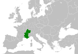
| 15:39, 22 Mejju 2016 |  | 485 × 340 (1.23 MB) | Alphathon | == {{int:filedesc}} == {{Inkscape}} {{Information |Description={{en|A map of the Kingdom of Arles/Arelat/Burgundy within Europe circa 1000 CE. The main subdivisions of the Byzantine Empire, Holy Roman Empire, Burgundy, France a... |
Użu tal-fajl
Il-Paġna segwenti twassal għal din l-istampa:
L-użu globali tal-fajl
Il-wikis segwenti jużaw dan il-fajl:
- Użu fuq ast.wikipedia.org
- Użu fuq az.wikipedia.org
- Użu fuq ca.wikipedia.org
- Użu fuq cs.wikipedia.org
- Użu fuq el.wikipedia.org
- Użu fuq en.wikipedia.org
- Użu fuq eo.wikipedia.org
- Użu fuq es.wikipedia.org
- Użu fuq fa.wikipedia.org
- Użu fuq fi.wikipedia.org
- Użu fuq fr.wikipedia.org
- Użu fuq he.wikipedia.org
- Użu fuq hu.wikipedia.org
- Użu fuq id.wikipedia.org
- Użu fuq it.wikipedia.org
- Użu fuq it.wikiquote.org
- Użu fuq ko.wikipedia.org
- Użu fuq lv.wikipedia.org
- Użu fuq pl.wikipedia.org
- Użu fuq ro.wikipedia.org
- Użu fuq sl.wikipedia.org
- Użu fuq th.wikipedia.org
- Użu fuq uk.wikipedia.org
- Użu fuq vi.wikipedia.org
- Użu fuq www.wikidata.org
- Użu fuq zh.wikipedia.org
.svg)