
Stampa:Kherson province physical map.svg

Size of this PNG preview of this SVG file: 532 × 403 pixels. Riżoluzzjonijiet oħra: 317 × 240 pixels | 634 × 480 pixels | 1,014 × 768 pixels | 1,280 × 970 pixels | 2,560 × 1,939 pixels
Fajl oriġinali (Fajl fil-format SVG, dimensjoni nominali 532 × 403 pixel, dimensjoni tal-fajl: 254 KB)
| Dan huwa fajl mill-Wikimedia Commons. Il-deskrizzjoni fuq il-paġna ta' diskussjoni oriġinali tidher hawn taħt.
|
Taqsira
| Deskrizzjoni |
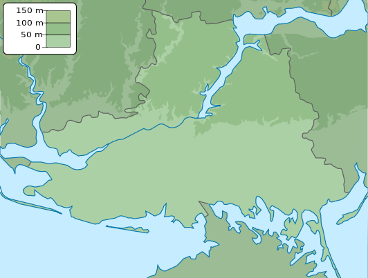
English: Physical map of Kherson province, Ukraine
Русский: Физическая карта Херсонской области, Украина |
| Data | |
| Sors | Opra proprja |
| Awtur | Urutseg |
Liċenzja
| I, the copyright holder of this work, release this work into the public domain. This applies worldwide. In some countries this may not be legally possible; if so: I grant anyone the right to use this work for any purpose, without any conditions, unless such conditions are required by law. |
Kronoloġija tal-fajl
Agħfas fuq il-grupp data/ħin biex tara l-fajl biex tara kif jidher dak il-ħin.
| Data/Ħin | Minjatura | Qisien | Utent | Kumment | |
|---|---|---|---|---|---|
| kurrenti | 19:13, 17 Marzu 2014 | | 532 × 403 (254 KB) | NordNordWest | more to the south |
| 18:21, 21 Diċembru 2010 |  | 532 × 361 (333 KB) | Urutseg | == {{int:filedesc}} == {{Information |Description= {{en|1=Physical map of Kherson province, Ukraine}} {{ru|1=Физическая карта Херсонской области, Украина}} |Source=own work |Date=2010-12-20 |Author=[[:user:Urutseg|Ur |
Użu tal-fajl
Il-Paġna segwenti twassal għal din l-istampa:
L-użu globali tal-fajl
Il-wikis segwenti jużaw dan il-fajl:
- Użu fuq ar.wikipedia.org
- Użu fuq avk.wikipedia.org
- Użu fuq ba.wikipedia.org
- Użu fuq bcl.wikipedia.org
- Użu fuq be.wikipedia.org
- Użu fuq bg.wikipedia.org
- Херсон
- Берислав
- Геническ
- Гола Пристан
- Каховка
- Нова Каховка
- Скадовск
- Таврийск
- Олешки
- Антонивка
- Архангелске
- Аскания Нова
- Била Криниця
- Билозерка
- Бриливка
- Велика Лепетиха
- Велика Олександривка
- Верхний Рогачик
- Високопиля
- Горностаивка
- Днипряни
- Зеленивка
- Иванивка
- Каланчак
- Калинивске
- Карерне
- Козацке
- Комишани
- Лазурне
- Любимивка
- Мирне (Херсонска област)
- Надднипрянске
- Нижни Сиргози
- Нова Маячка
- Нововоронцовка
- Новоолексиивка
- Новотроицке
- Рикове (Украйна)
- Сиваске
- Чаплинка
Ara l-użu globali ta' dan il-fajl.