
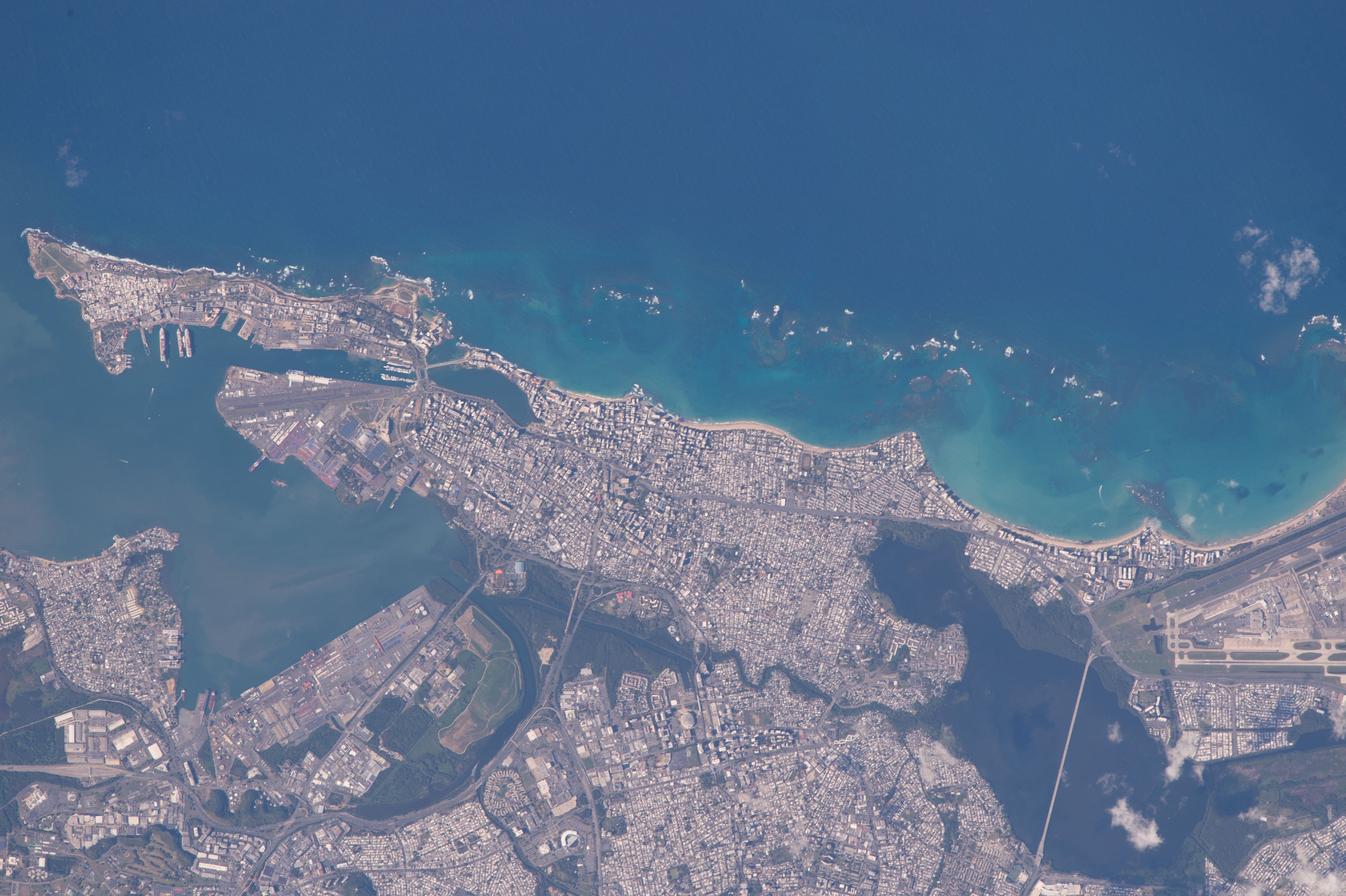
Stampa:ISS047-E-783 - View of Puerto Rico.jpg
Daqs tad-dehra proviżorja: 800 × 532 pixels. Riżoluzzjonijiet oħra: 320 × 213 pixels | 640 × 426 pixels | 1,024 × 682 pixels | 1,280 × 852 pixels | 2,560 × 1,704 pixels | 4,928 × 3,280 pixels
Fajl oriġinali (4,928 × 3,280 pixel, dimensjoni: 2.85 MB, tip ta' MIME: image/jpeg)
| Dan huwa fajl mill-Wikimedia Commons. Il-deskrizzjoni fuq il-paġna ta' diskussjoni oriġinali tidher hawn taħt.
|
Taqsira
| Deskrizzjoni |
English: View of Puerto Rico taken during ISS Expedition 47. |
| Data | |
| Sors | JSC Gateway to Astronaut Photography of Earth |
| Awtur | Earth Science and Remote Sensing Unit, Lyndon B. Johnson Space Center |
| Mission | ISS047 |
| Roll | E |
| Frame | 783 |
| Geographic area | Puerto Rico |
| Features | SAN JUAN, HARBOR, REEFS, AIRPORT, BAYS, LAGOONS, URBAN AREAS |
| Cloud percentage | 10% |
| Altitude | 216 nautical miles (400 km) |
| Look angle | 13 |
| Look direction | NE |
| Sun Azimuth | 248° |
| Sun Elevation | 35° |
| Camera | Nikon D4 Electronic Still Camera |
| Focal length | 1150 mm |
| Camera location | | View this and other nearby images on: OpenStreetMap |
|---|
| Object location | | View this and other nearby images on: OpenStreetMap |
|---|
This image or video was catalogued by Johnson Space Center of the United States National Aeronautics and Space Administration (NASA) under Photo ID: ISS047-E-783. This tag does not indicate the copyright status of the attached work. A normal copyright tag is still required. See Commons:Licensing. Other languages:
|
Liċenzja
| This file is in the public domain in the United States because it was solely created by NASA. NASA copyright policy states that "NASA material is not protected by copyright unless noted". (See Template:PD-USGov, NASA copyright policy page or JPL Image Use Policy.) | ||
 |
Warnings:
|
Kronoloġija tal-fajl
Agħfas fuq il-grupp data/ħin biex tara l-fajl biex tara kif jidher dak il-ħin.
| Data/Ħin | Minjatura | Qisien | Utent | Kumment | |
|---|---|---|---|---|---|
| kurrenti | 02:09, 3 Frar 2022 | | 4,928 × 3,280 (2.85 MB) | The Eloquent Peasant | rotated 180 degrees to reflect how it's normally seen in maps |
| 00:26, 22 Marzu 2021 |  | 4,928 × 3,280 (1.94 MB) | Askeuhd |
Użu tal-fajl
Il-Paġna segwenti twassal għal din l-istampa:
L-użu globali tal-fajl
Il-wikis segwenti jużaw dan il-fajl:
- Użu fuq en.wikipedia.org