
Stampa:Egypt 1450 BC.svg

Size of this PNG preview of this SVG file: 520 × 600 pixels. Riżoluzzjonijiet oħra: 208 × 240 pixels | 416 × 480 pixels | 666 × 768 pixels | 887 × 1,024 pixels | 1,775 × 2,048 pixels | 1,300 × 1,500 pixels
Fajl oriġinali (Fajl fil-format SVG, dimensjoni nominali 1,300 × 1,500 pixel, dimensjoni tal-fajl: 257 KB)
| Dan huwa fajl mill-Wikimedia Commons. Il-deskrizzjoni fuq il-paġna ta' diskussjoni oriġinali tidher hawn taħt.
|
Taqsira
| Deskrizzjoni |
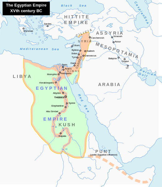
English: Map of the Middle East 1450 BC (by ArdadN)
Čeština: Největší územní rozsah starověkého Egypta, za vlády Thutmose I. |
| Sors |
The original description page was here. All following user names refer to en.wikipedia.
|
| Awtur | ArdadN at Ingliż Wikipedija |
| Verżjonijiet oħra |
[]
|


|
This SVG file contains embedded text that can be translated into your language, using any capable SVG editor, text editor or the SVG Translate tool. For more information see: About translating SVG files. |
Liċenzja
| I, the copyright holder of this work, release this work into the public domain. This applies worldwide. In some countries this may not be legally possible; if so: I grant anyone the right to use this work for any purpose, without any conditions, unless such conditions are required by law. |
Kronoloġija tal-fajl
Agħfas fuq il-grupp data/ħin biex tara l-fajl biex tara kif jidher dak il-ħin.
| Data/Ħin | Minjatura | Qisien | Utent | Kumment | |
|---|---|---|---|---|---|
| kurrenti | 22:18, 23 Settembru 2023 | | 1,300 × 1,500 (257 KB) | Gaaryeelidmaan | Punt was associated with Myrrh trade, a product found in modern Puntland https://www.worldhistory.org/punt/ |
| 05:28, 9 Ottubru 2013 |  | 1,300 × 1,500 (257 KB) | Lymantria | Reverted to version as of 00:24, 10 August 2008 | |
| 16:05, 7 Ottubru 2013 |  | 1,300 × 1,500 (238 KB) | Emara | تعريب الخريطة | |
| 00:24, 10 Awwissu 2008 |  | 1,300 × 1,500 (257 KB) | Leoboudv | {{Information |Description=Map of the Middle East 1450 BC |Source=The original description page is/was [http://en.wikipedia.org/w/index.php?title=Image%3AEgypt_1450_BC.svg here]. All following user names refer to en.wikipedia. * 2008-05-07 09:18 [[:en:Use |
Użu tal-fajl
L-ebda paġna fuq il-Wikipedija Maltija torbot lejn dan il-fajl.
L-użu globali tal-fajl
Il-wikis segwenti jużaw dan il-fajl:
- Użu fuq ast.wikipedia.org
- Użu fuq azb.wikipedia.org
- Użu fuq az.wikipedia.org
- Użu fuq ba.wikipedia.org
- Użu fuq be.wikipedia.org
- Użu fuq bg.wikipedia.org
- Użu fuq bn.wikipedia.org
- Użu fuq ca.wikipedia.org
- Użu fuq cv.wikipedia.org
- Użu fuq de.wikipedia.org
- Użu fuq el.wikipedia.org
- Użu fuq en.wikipedia.org
- Timeline of Jerusalem
- Thutmose I
- The Bible Unearthed
- List of conflicts in Asia
- Middle Eastern empires
- List of conflicts in Egypt
- Land of Punt
- Transjordan (region)
- List of conflicts in Sudan
- List of conflicts in Libya
- User:Falcaorib
- Talk:The Exodus/Archive 18
- User:SomeGuyWhoRandomlyEdits/List of conflicts in the Near East
- Użu fuq eu.wikipedia.org
- Użu fuq fa.wikipedia.org
- Użu fuq gl.wikipedia.org
- Użu fuq hi.wikipedia.org
- Użu fuq hy.wikipedia.org
- Użu fuq hyw.wikipedia.org
- Użu fuq id.wikipedia.org
- Użu fuq id.wikibooks.org
- Użu fuq is.wikipedia.org
- Użu fuq it.wikipedia.org
- Użu fuq ja.wikipedia.org
Ara l-użu globali ta' dan il-fajl.