
Stampa:China blank map.svg

Size of this PNG preview of this SVG file: 705 × 599 pixels. Riżoluzzjonijiet oħra: 282 × 240 pixels | 565 × 480 pixels | 904 × 768 pixels | 1,205 × 1,024 pixels | 2,409 × 2,048 pixels | 1,000 × 850 pixels
Fajl oriġinali (Fajl fil-format SVG, dimensjoni nominali 1,000 × 850 pixel, dimensjoni tal-fajl: 135 KB)
| Dan huwa fajl mill-Wikimedia Commons. Il-deskrizzjoni fuq il-paġna ta' diskussjoni oriġinali tidher hawn taħt.
|
| Deskrizzjoni |
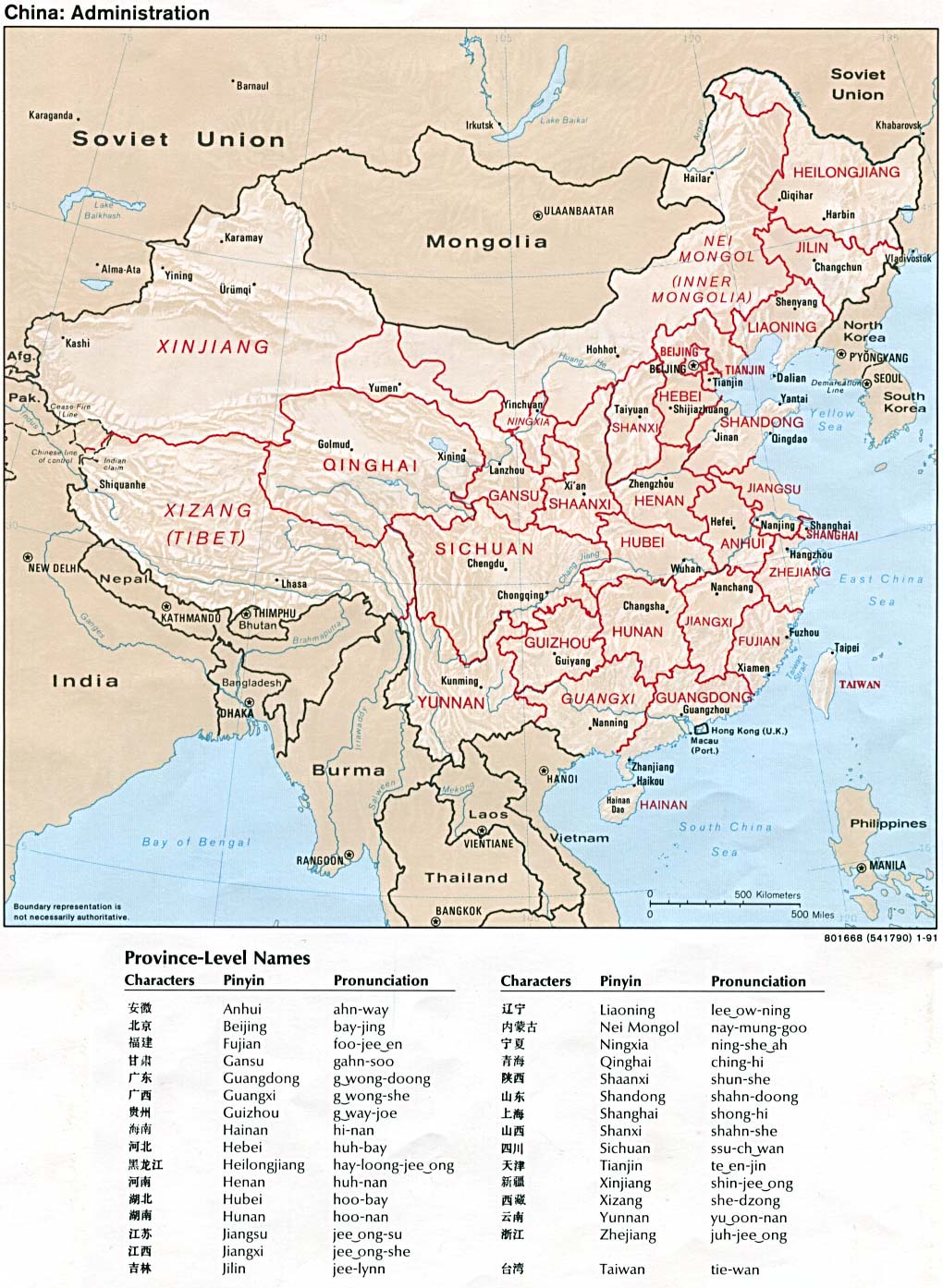
A blank SVG map of China Legend: |
||
| Data | |||
| Sors |
self-made; based on CIA public domain maps: |
||
| Awtur | Joowwww | ||
| Permess (Użu mill-ġdid tal-fajl) |
|
||
| Verżjonijiet oħra |
Derivative works of this file: |
Kronoloġija tal-fajl
Agħfas fuq il-grupp data/ħin biex tara l-fajl biex tara kif jidher dak il-ħin.
| Data/Ħin | Minjatura | Qisien | Utent | Kumment | |
|---|---|---|---|---|---|
| kurrenti | 12:14, 30 Marzu 2019 | | 1,000 × 850 (135 KB) | Newfraferz87 | 1. Reinstated separate border class 2. Removed borders from individual provinces Now similar to earlier file, but is text-editor friendly. Avoid using Inkscape for editing. |
| 12:10, 30 Marzu 2019 |  | 1,000 × 850 (111 KB) | Newfraferz87 | 1. Redrew canvas (teal) 2. Divided main China shape down to individual provinces for coloring (yellow) 3. Grouped styles 4. Added IDs & classes | |
| 16:11, 13 Awwissu 2008 |  | 1,000 × 850 (205 KB) | Joowwww | added missing laos/vietnam border | |
| 20:24, 14 Mejju 2008 |  | 1,000 × 850 (204 KB) | Joowwww | Reverted to version as of 11:03, 14 May 2008, discussion underway | |
| 20:00, 14 Mejju 2008 |  | 1,000 × 850 (204 KB) | Isageum | The colors on the disputed territories are not clear and confusing, so distinctive colors are added. * Beige - People's Public of China * Yellow - Disputed areas controlled by People's Public of China * Orange - Disputed areas controlled by others. | |
| 11:03, 14 Mejju 2008 |  | 1,000 × 850 (204 KB) | Joowwww | adjusted gansu/qinghai border, removed off-screen baggage | |
| 11:05, 6 Mejju 2008 |  | 1,000 × 850 (212 KB) | Joowwww | changed colours | |
| 21:26, 5 Mejju 2008 |  | 1,000 × 850 (212 KB) | Joowwww | {{Information |Description=A blank SVG map of China |Source=self-made |Date=2008-05-05 |Author= Joowwww |Permission={{PD-self}} |other_versions= }} |
Użu tal-fajl
L-ebda paġna fuq il-Wikipedija Maltija torbot lejn dan il-fajl.
L-użu globali tal-fajl
Il-wikis segwenti jużaw dan il-fajl:
- Użu fuq ar.wikipedia.org
- Użu fuq ban.wikipedia.org
- Użu fuq de.wikipedia.org
- Użu fuq en.wikipedia.org
- Użu fuq es.wikipedia.org
- Użu fuq fr.wikipedia.org
- Użu fuq he.wikipedia.org
- Użu fuq kbd.wikipedia.org
- Użu fuq pt.wikipedia.org