
Stampa:Ceuta en.png

Daqs tad-dehra proviżorja: 800 × 417 pixels. Riżoluzzjonijiet oħra: 320 × 167 pixels | 640 × 333 pixels | 1,024 × 533 pixels | 1,280 × 667 pixels | 1,993 × 1,038 pixels
Fajl oriġinali (1,993 × 1,038 pixel, dimensjoni: 457 KB, tip ta' MIME: image/png)
| Dan huwa fajl mill-Wikimedia Commons. Il-deskrizzjoni fuq il-paġna ta' diskussjoni oriġinali tidher hawn taħt.
|

|
This image could be re-created using vector graphics as an SVG file. This has several advantages; see Commons:Media for cleanup for more information. If an SVG form of this image is available, please upload it and afterwards replace this template with
{{vector version available|new image name}}.
It is recommended to name the SVG file “Ceuta en.svg”—then the template Vector version available (or Vva) does not need the new image name parameter. |
Taqsira
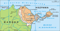
English: Map of Ceuta, Spain. The original image is Image:Ceuta.png
Author
Author Aotearoa, translated by Hoshie
.png)
Liċenzja
Jiena, id-detentur tal-copyright ta' dan ix-xogħol, niddikjara li se nippubblikah taħt il-liċenzja segwenti:

|
Huwa permess li tikkopja, tiddistribwixxi u/jew timmodifika dan id-dokument abbażi tat-termini tal-Liċenzja ta' Dokumentazzjoni Ħielsa tal-GNU, Verżjoni 1.2 jew kwalunkwe verżjoni oħra pubblikata mill-Free Software Foundation; mingħajr ebda sezzjoni non-modifikabbli, mingħajr test tal-faċċata u mingħajr test tal-qoxra. Kopja tal-liċenzja hi inkluża fis-sezzjoni intitolata Test tal-Liċenzja ta' Dokumentazzjoni Ħielsa tal-GNU". |
| Dan il-fajl huwa liċenzjat taħt it-termini tal-liċenzja Creative Commons Attribuzzjoni-Aqsam bl-istess mod 3.0 Unported | ||
| ||
| This licensing tag was added to this file as part of the GFDL licensing update. |
See also
-
 Spanish captions.
 -
 Polish captions.


Kronoloġija tal-fajl
Agħfas fuq il-grupp data/ħin biex tara l-fajl biex tara kif jidher dak il-ħin.
| Data/Ħin | Minjatura | Qisien | Utent | Kumment | |
|---|---|---|---|---|---|
| kurrenti | 12:53, 16 Lulju 2010 | | 1,993 × 1,038 (457 KB) | Aotearoa | Reverted to version as of 04:21, 18 December 2006 |
| 06:21, 4 Lulju 2010 |  | 1,993 × 1,038 (383 KB) | Omar-Toons | better map, adapted from the Spanish npov image. | |
| 05:58, 4 Lulju 2010 |  | 1,993 × 1,038 (381 KB) | Omar-Toons | npov: Perejil is recognised as a neutral territory | |
| 04:21, 18 Diċembru 2006 |  | 1,993 × 1,038 (457 KB) | Hoshie | {{en|Map of Ceuta and the Perejil Island, in Spain. The original image is Image:Ceuta.png}} == Author == Author Aotearoa, translated by ~~~ == License== {{self|GFDL}} *** Category:Maps of Spain |
Użu tal-fajl
Il-Paġna segwenti twassal għal din l-istampa:
L-użu globali tal-fajl
Il-wikis segwenti jużaw dan il-fajl:
- Użu fuq ar.wikipedia.org
- Użu fuq bn.wikipedia.org
- Użu fuq ca.wikipedia.org
- Użu fuq en.wikipedia.org
- Użu fuq he.wikipedia.org
- Użu fuq hr.wikipedia.org
- Użu fuq incubator.wikimedia.org
- Użu fuq ja.wikipedia.org
- Użu fuq pt.wikipedia.org
- Użu fuq uk.wikipedia.org
- Użu fuq yo.wikipedia.org