Aqbeż għall-kontentut

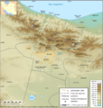
Stampa:Carte Topo Region Teheran.png

Page contents not supported in other languages.
Minn Wikipedija, l-enċiklopedija l-ħielsa

Fajl oriġinali (2,176 × 2,300 pixel, dimensjoni: 3.89 MB, tip ta' MIME: image/png)

Dan huwa fajl mill-Wikimedia Commons. Il-deskrizzjoni fuq il-paġna ta' diskussjoni oriġinali tidher hawn taħt.
Commons huwa repożitorju ta' fajls multimedjali liċenzjati b'xejn. Int tista' tgħin.

Taqsira

Deskrizzjoni
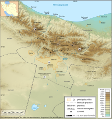
English: Topographic map in French of the Tehran area in Iran.
Note : The shaded relief is a raster image embedded in the SVG file.
Français : Carte topographique en français de la région de fr:Téhéran (Iran).
Note : Le relief ombré est une image bitmap embarquée dans le fichier SVG.

UTM projection ; WGS84 datum ; shaded relief (composite image of N-W, W and N lightning positions) ;
Approximate scales:

  • Topography: 1:372,000 (precision: 93 m) ;
Data
Sors

http://www.liranpourlesnuls.net/cartes/carte-teheran-et-sa-region/

Awtur Fabien Dany
Permess
(Użu mill-ġdid tal-fajl)

L'utilisation est autorisée selon les termes ci-dessous et à condition de citer comme source : L'Iran pour les nuls www.liranpourlesnuls.net. Un email serait aussi grandement apprécié.

VRT Wikimedia

This work is free and may be used by anyone for any purpose. If you wish to use this content, you do not need to request permission as long as you follow any licensing requirements mentioned on this page.

The Wikimedia Foundation has received an e-mail confirming that the copyright holder has approved publication under the terms mentioned on this page. This correspondence has been reviewed by a Volunteer Response Team (VRT) member and stored in our permission archive. The correspondence is available to trusted volunteers as ticket #2011013010010561.

If you have questions about the archived correspondence, please use the VRT noticeboard. Ticket link: https://ticket.wikimedia.org/otrs/index.pl?Action=AgentTicketZoom&TicketNumber=2011013010010561
Find other files from the same ticket: SDC query (SPARQL)

Verżjonijiet oħra
SVG Version
Camera location35° 43′ 36.3″ N, 51° 26′ 26.6″ E Kartographer map based on OpenStreetMap.View this and other nearby images on: OpenStreetMapinfo

Liċenzja

w:mt:Creative Commons
attribuzzjoni Ixxerja bl-istess mod
Dan il-fajl huwa liċenzjat taħt it-termini tal-liċenzja Creative Commons Attribuzzjoni-Aqsam bl-istess mod 3.0 Unported
Inti ħieles:
  • li taqsam – li tikkopja, tiddistribwixxi u tittrażmetti din l-opra
  • li timmodifika – li tadatta l-biċċa xogħol
Taħt il-kundizzjonijiet segwenti:
  • attribuzzjoni – Għandek tattribwixxi x-xogħol bil-mod speċifikat mill-awtur jew minn min ta l-l-iċenzja (imma mhux b'xi mod li jissuġġerixxi ji jappoġjaw lilek jew l-użu tax-xogħol).
  • Ixxerja bl-istess mod – Jekk tbiddel, tittrasforma jew tibni fuq dan il-materjal, inti għandek bżonn taqsam il-kontribuzzjonijiet tiegħek taħt l-istess liċenzja jew waħda li taqbel ma' dik oriġinali.

This image has been assessed using the Quality image guidelines and is considered a Quality image.

العربية  جازايرية  беларуская  беларуская (тарашкевіца)  български  বাংলা  català  čeština  Cymraeg  Deutsch  Schweizer Hochdeutsch  Zazaki  Ελληνικά  English  Esperanto  español  eesti  euskara  فارسی  suomi  français  galego  עברית  हिन्दी  hrvatski  magyar  հայերեն  Bahasa Indonesia  italiano  日本語  Jawa  ქართული  한국어  kurdî  Lëtzebuergesch  lietuvių  македонски  മലയാളം  मराठी  Bahasa Melayu  Nederlands  Norfuk / Pitkern  polski  português  português do Brasil  rumantsch  română  русский  sicilianu  slovenčina  slovenščina  shqip  српски / srpski  svenska  தமிழ்  తెలుగు  ไทย  Tagalog  toki pona  Türkçe  українська  vèneto  Tiếng Việt  中文  中文(简体)  中文(繁體)  +/−

Captions

Add a one-line explanation of what this file represents

Items portrayed in this file

depicts Ingliż

copyrighted Ingliż

30 Jannar 2011

35°43'36.300"N, 51°26'26.599"E

media type Ingliż

image/png

checksum Ingliż

c3e24f997840df1ca2f829fae132b8269ef95080

data size Ingliż

4,079,482 byte

height Ingliż

2,300 pixel

width Ingliż

2,176 pixel

Kronoloġija tal-fajl

Agħfas fuq il-grupp data/ħin biex tara l-fajl biex tara kif jidher dak il-ħin.

Data/ĦinMinjaturaQisienUtentKumment
kurrenti22:11, 30 Jannar 2011Minjatura tal-verżjoni ta' 22:11, 30 Jannar 20112,176 × 2,300 (3.89 MB)Fabienkhan{{Information |Description ={{en|1=Topographic map in French of the Tehran area in Iran.<br/>''Note :'' The shaded relief is a raster image embedded in the SVG file.}} {{fr|1=Carte topographique en français de la région de [[:fr:Téhé

Il-Paġna segwenti twassal għal din l-istampa:

L-użu globali tal-fajl

Il-wikis segwenti jużaw dan il-fajl: