
Stampa:Camargue map.png
Mhux disponibli verżjonijiet b'risoluzzjoni akbar.
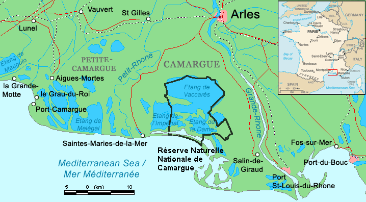
Camargue_map.png (718 × 396 pixel, dimensjoni: 42 KB, tip ta' MIME: image/png)
| Dan huwa fajl mill-Wikimedia Commons. Il-deskrizzjoni fuq il-paġna ta' diskussjoni oriġinali tidher hawn taħt.
|
Taqsira
| Deskrizzjoni | ||||
| Data | ||||
| Sors | Combination of CIA World Factbook map (Image:Fr-map.png) and Demis Map Server (http://www2.demis.nl/mapserver/mapper.asp) data with additional annotations and modifications by self. | |||
| Awtur | ChrisO | |||
| Verżjonijiet oħra |
File:Camargue, Petite Caramgue et Parc naturel reg.png (relaunched and actualized)
|

Kronoloġija tal-fajl
Agħfas fuq il-grupp data/ħin biex tara l-fajl biex tara kif jidher dak il-ħin.
| Data/Ħin | Minjatura | Qisien | Utent | Kumment | |
|---|---|---|---|---|---|
| kurrenti | 21:34, 29 April 2016 | | 718 × 396 (42 KB) | Rsuessbr | Writing of Petite-Camargue corrected |
| 17:15, 10 Awwissu 2015 |  | 718 × 396 (42 KB) | Rsuessrb | Added: limits of the natural park (according to a map published by snpn (Société Nationale de Protection de la Nature), 2015 | |
| 01:23, 20 Marzu 2012 |  | 718 × 396 (38 KB) | Ras67 | cropped | |
| 20:52, 16 Awwissu 2006 |  | 720 × 398 (41 KB) | ChrisO | Map of the Camargue region, southern France By ~~~, derived from open source mapping | |
| 20:46, 16 Awwissu 2006 |  | 720 × 398 (40 KB) | ChrisO | Map of the Camargue region, southern France By ~~~, derived from open source mapping |
Użu tal-fajl
Il-Paġna segwenti twassal għal din l-istampa:
L-użu globali tal-fajl
Il-wikis segwenti jużaw dan il-fajl:
- Użu fuq af.wikipedia.org
- Użu fuq ar.wikipedia.org
- Użu fuq az.wikipedia.org
- Użu fuq br.wikipedia.org
- Użu fuq co.wikipedia.org
- Użu fuq cs.wikipedia.org
- Użu fuq cy.wikipedia.org
- Użu fuq de.wikipedia.org
- Użu fuq en.wikipedia.org
- Użu fuq eo.wikipedia.org
- Użu fuq es.wikipedia.org
- Użu fuq fi.wikipedia.org
- Użu fuq fr.wikipedia.org
- Użu fuq gl.wikipedia.org
- Użu fuq hu.wikipedia.org
- Użu fuq id.wikipedia.org
- Użu fuq it.wikipedia.org
- Użu fuq ja.wikipedia.org
- Użu fuq ko.wikipedia.org
- Użu fuq lt.wikipedia.org
- Użu fuq nl.wikipedia.org
- Użu fuq nn.wikipedia.org
- Użu fuq no.wikipedia.org
- Użu fuq oc.wikipedia.org
Ara l-użu globali ta' dan il-fajl.