
Stampa:Alamannien Hochburgund ca 1000.png
Daqs tad-dehra proviżorja: 711 × 599 pixels. Riżoluzzjonijiet oħra: 285 × 240 pixels | 570 × 480 pixels | 911 × 768 pixels | 1,215 × 1,024 pixels | 2,500 × 2,107 pixels
Fajl oriġinali (2,500 × 2,107 pixel, dimensjoni: 1.11 MB, tip ta' MIME: image/png)
| Dan huwa fajl mill-Wikimedia Commons. Il-deskrizzjoni fuq il-paġna ta' diskussjoni oriġinali tidher hawn taħt.
|
Taqsira
| Deskrizzjoni |
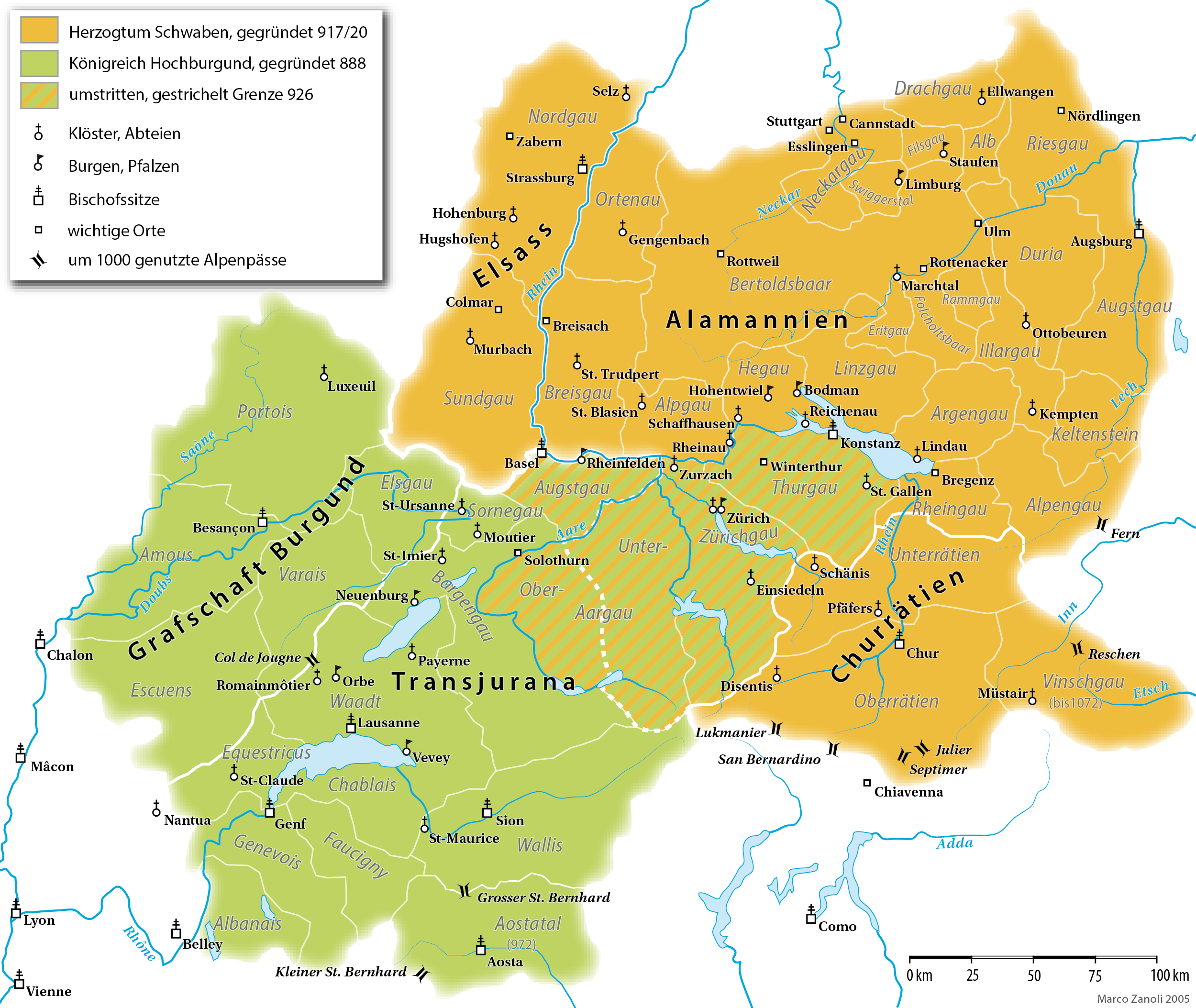
English: A map (in German) of the Duchy of Alamannia and the Kingdom of Upper Burgundy in the 10th century. |
| Data | |
| Sors | own work; G. Droysen: Allgemeiner Historischer Handatlas. Bielefeld / Leipzig, 1886, 22f. |
| Awtur | Marco Zanoli |
| Verżjonijiet oħra |
|


|
This historical map image could be re-created using vector graphics as an SVG file. This has several advantages; see Commons:Media for cleanup for more information. If an SVG form of this image is available, please upload it and afterwards replace this template with
{{vector version available|new image name}}.
It is recommended to name the SVG file “Alamannien Hochburgund ca 1000.svg”—then the template Vector version available (or Vva) does not need the new image name parameter. |
Liċenzja
You may use my work outside wikipedia for free as long as you name me as the author. If you would like to use my work in a print medium, please send me a specimen copy.
Contact me if you have questions regarding the license or if you want individual changes to the map (marco.zanoli at hotmail.ch). This file is licensed under the Creative Commons Attribution-Share Alike 4.0 International license. Attribuzzjoni: Marco Zanoli
|
Kronoloġija tal-fajl
Agħfas fuq il-grupp data/ħin biex tara l-fajl biex tara kif jidher dak il-ħin.
| Data/Ħin | Minjatura | Qisien | Utent | Kumment | |
|---|---|---|---|---|---|
| kurrenti | 16:49, 10 April 2021 | | 2,500 × 2,107 (1.11 MB) | Sidonius | Lukmanier und San Bernardino vertauscht |
| 14:11, 28 Marzu 2021 |  | 2,500 × 2,107 (1.12 MB) | Sidonius | kleinere Korrekturen, Gaue auch in Hochburgund in modernen Namen | |
| 18:49, 15 Novembru 2020 |  | 1,500 × 1,319 (550 KB) | FootKalos1597 | Added informations | |
| 08:08, 19 Frar 2019 |  | 1,500 × 1,319 (534 KB) | Sidonius | - Chiavenna entfernt, da erst 1157 zu Schwaben | |
| 16:15, 18 Frar 2019 |  | 1,500 × 1,319 (535 KB) | Sidonius | - Kloster St-Claude eingezeichnet - Beschriftung weiss hinterlegt - Vinschgau übereinstimmend mit Forschung zu Churrätien als Teil des Hzm. Schwaben eingezeichnet | |
| 13:24, 20 Jannar 2019 |  | 1,500 × 1,319 (414 KB) | Sidonius | - Abtei Hugshofen eingezeichnet - Aostatal als Teil von Hochburgund | |
| 14:22, 13 Jannar 2019 |  | 1,500 × 1,285 (404 KB) | Sidonius | weitere Fehler korrigiert, zusätzliche Orte eingezeichnet, Legende überarbeitet, Grenzen korrigiert gemäss Historischem Lexikon der CH | |
| 15:36, 12 Jannar 2019 |  | 1,500 × 1,288 (392 KB) | Sidonius | kleinere Fehler behoben in Beschriftungen, Farben noch etwas angepasst | |
| 23:10, 26 Novembru 2012 |  | 1,500 × 1,322 (252 KB) | Hawky.diddiz | Lossless optimization | |
| 11:54, 23 Mejju 2011 |  | 1,500 × 1,322 (433 KB) | Sidonius | letzter Versuch, die korrigierte Datei einzubinden |
Użu tal-fajl
Il-Paġna segwenti twassal għal din l-istampa:
L-użu globali tal-fajl
Il-wikis segwenti jużaw dan il-fajl:
- Użu fuq als.wikipedia.org
- Użu fuq an.wikipedia.org
- Użu fuq ar.wikipedia.org
- Użu fuq arz.wikipedia.org
- Użu fuq ast.wikipedia.org
- Użu fuq bg.wikipedia.org
- Użu fuq br.wikipedia.org
- Użu fuq ca.wikipedia.org
- Użu fuq cs.wikipedia.org
- Użu fuq cy.wikipedia.org
- Użu fuq de.wikipedia.org
Ara l-użu globali ta' dan il-fajl.