
Stampa:AMH-6775-KB Siege of Batavia by the sultan of Mataram.jpg
Daqs tad-dehra proviżorja: 717 × 600 pixels. Riżoluzzjonijiet oħra: 287 × 240 pixels | 574 × 480 pixels | 918 × 768 pixels | 1,224 × 1,024 pixels | 2,400 × 2,008 pixels
Fajl oriġinali (2,400 × 2,008 pixel, dimensjoni: 723 KB, tip ta' MIME: image/jpeg)
| Dan huwa fajl mill-Wikimedia Commons. Il-deskrizzjoni fuq il-paġna ta' diskussjoni oriġinali tidher hawn taħt.
|
Taqsira
Nederlands: Belegering van Batavia door de sultan van Mataram
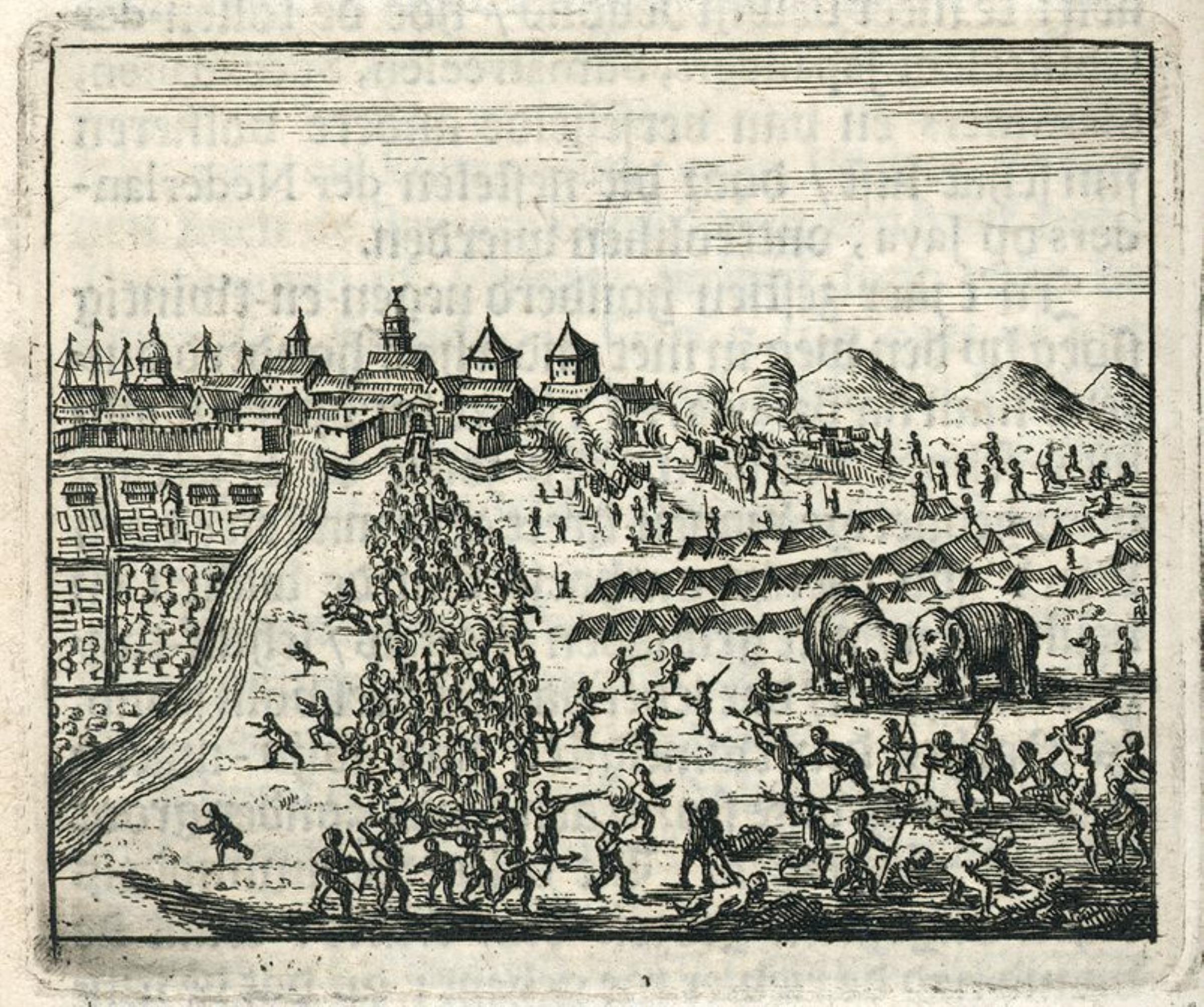
English: Siege of Batavia by the sultan of Mataram( |
|||||||||||||||||||||
|---|---|---|---|---|---|---|---|---|---|---|---|---|---|---|---|---|---|---|---|---|---|
| Awtur |
Nederlands: Anoniem / Anonymous (graveur / etser), Aart Dircksz Oossaan (uitgever), Sander Wybrants (uitgever)
English: Anoniem / Anonymous (engraver / etcher), Aart Dircksz Oossaan (publisher), Sander Wybrants (publisher) |
||||||||||||||||||||
| Titlu |
Nederlands: Belegering van Batavia door de sultan van Mataram
English: Siege of Batavia by the sultan of Mataram |
||||||||||||||||||||
| Deskrizzjoni |
Nederlands: Belegering van Batavia door de sultan van Mataram.
In 1628 viel de VOC-stad Batavia ten prooi aan de veroveringsdrang van Sultan Agoeng van Mataram. De sultan zou met de inlijving van Batavia bijna het hele eiland Java in handen krijgen. Het voortbestaan van de VOC op Java kwam op het spel te staan. De muren van het kort daarvoor voltooide fort Batavia bleken bestand tegen de serie aanvallen vanuit het achterland door de troepen van Sultan Agoeng van Mataram. Door voedselgebrek van zijn troepen moest de sultan de strijd beëindigen.
English: Siege of Batavia by the sultan of Mataram.
In 1628 the VOC city of Batavia fell victim to Sultan Agoeng of Mataram's will to conquer. By capturing Batavia the sultan would have acquired almost the whole island of Java. Consequently the future of the VOC on Java hung in the balance. But the walls of the recently completed Batavia Fort proved strong enough to resist the series of attacks from the hinterland by the armies of Sultan Agoeng of Mataram. Because of lack of food for the troops the sultan was forced to withdraw. |
||||||||||||||||||||
| Data | after 1680 | ||||||||||||||||||||
| Teknika |
Nederlands: gravure op papier
English: engraving on paper |
||||||||||||||||||||
| Qisien | height: 6 cm;width: 7 cm | ||||||||||||||||||||
| Collection |
|
||||||||||||||||||||
| Numru ta' adeżjoni |
511 K 23 p. 358 |
||||||||||||||||||||
| Noti |
English: Subjects: house, battle / taking / war (fight), fauna, Person, European, encampment / military base, building, survey / view, Asians & Africans
Nederlands: Onderwerpen: huis / woonhuis, veldslag / oorlog (strijd) / inname, fauna, Persoon, Europeanen, kampement / legerplaats, gebouw, overzicht / aanzicht, Aziaten & Afrikanen |
||||||||||||||||||||
| Sors/Fotografu |
|
||||||||||||||||||||
| Permess (Użu mill-ġdid tal-fajl) |
|
||||||||||||||||||||

| Object location | | View this and other nearby images on: OpenStreetMap |
|---|
Kronoloġija tal-fajl
Agħfas fuq il-grupp data/ħin biex tara l-fajl biex tara kif jidher dak il-ħin.
| Data/Ħin | Minjatura | Qisien | Utent | Kumment | |
|---|---|---|---|---|---|
| kurrenti | 11:28, 10 Ġunju 2014 | | 2,400 × 2,008 (723 KB) | HuskyBot | == {{int:filedesc}} == {{Artwork |title = {{nl|1=Belegering van Batavia door de sultan van Mataram}} {{en|1=Siege of Batavia by the sultan of Mataram}} |description = {{nl|1=Belegering van Batavia door de sulta... |
Użu tal-fajl
Il-Paġna segwenti twassal għal din l-istampa:
L-użu globali tal-fajl
Il-wikis segwenti jużaw dan il-fajl:
- Użu fuq de.wikipedia.org
- Użu fuq en.wikipedia.org
- Użu fuq fi.wikipedia.org
- Użu fuq fr.wikipedia.org
- Użu fuq id.wikipedia.org
- Użu fuq it.wikipedia.org
- Użu fuq nl.wikipedia.org
- Użu fuq uk.wikipedia.org
- Użu fuq www.wikidata.org