
Stampa:AMH-6670-NA Map of the island of Formosa.jpg

Fajl oriġinali (2,400 × 1,662 pixel, dimensjoni: 691 KB, tip ta' MIME: image/jpeg)
| Dan huwa fajl mill-Wikimedia Commons. Il-deskrizzjoni fuq il-paġna ta' diskussjoni oriġinali tidher hawn taħt.
|
Taqsira
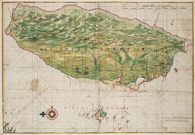
Nederlands: Kaart van het eiland Formosa
English: Map of the island of Formosa( |
||||||||||||||||||||||||
|---|---|---|---|---|---|---|---|---|---|---|---|---|---|---|---|---|---|---|---|---|---|---|---|---|
| Awtur |
Nederlands: Johannes Vingboons (landmeter / kaartenmaker)
English: Johannes Vingboons (land surveyor / mapmaker) |
|||||||||||||||||||||||
| Titlu |
Nederlands: Kaart van het eiland Formosa
English: Map of the island of Formosa |
|||||||||||||||||||||||
| Deskrizzjoni |
Nederlands: Titel catalogus Leupe (Nationaal Archief): Kaart van de kusten van Formosa en de Pescadores.
Lodingen aangegeven op de kaart. Op de achterzijde zijn strookjes papier geplakt met daarop letters en woorden geschreven die echter geen samenhangende tekst vormen. De contouren van Formosa en de Pescadores zijn op deze kaart exact dezelfde als die in de Atlas Blaeu-Van der Hem uit de Österreichische Nationalbibiothek , Wenen, inv. nr. Van der Hem 41:02.English: Title in the Leupe catalogue (National Archives): Kaart van de kusten van Formosa en de Pescadores.
Soundings indicated on the chart. Strips of paper have been pasted on the reverse. The strips bear letters and words, but these do not combine into a coherent text. The outlines of The island Formosa and the Pescadores on this map are exactly the same as the ones on the map in the Atlas Blaeu-Van der Hem from the Österreichische Nationalbibiothek , Vienna, inv. nr. Van der Hem 41:02. |
|||||||||||||||||||||||
| Data | circa 1665 | |||||||||||||||||||||||
| Teknika |
Nederlands: aquarel/waterverf op papier
English: watercolour on paper |
|||||||||||||||||||||||
| Qisien | height: 68 cm;width: 47 cm | |||||||||||||||||||||||
| Collection |
|
|||||||||||||||||||||||
| Numru ta' adeżjoni |
NL-HaNA_4.VELH_619.52 (old number: VELH0619.52) |
|||||||||||||||||||||||
| Skrizzjonijiet |
Het Eylant Formosa
|
|||||||||||||||||||||||
| Noti |
English: Subjects: chart / map / plan, compass / dial
Nederlands: Onderwerpen: plattegrond / kaart, kompas / windroos
English: Post: this image is related to a VOC trading post called Chi-lung |
|||||||||||||||||||||||
| Sors/Fotografu |
|
|||||||||||||||||||||||
| Permess (Użu mill-ġdid tal-fajl) |
|
|||||||||||||||||||||||
| Verżjonijiet oħra |
|
|||||||||||||||||||||||


| Object location | | View this and other nearby images on: OpenStreetMap |
|---|
Kronoloġija tal-fajl
Agħfas fuq il-grupp data/ħin biex tara l-fajl biex tara kif jidher dak il-ħin.
| Data/Ħin | Minjatura | Qisien | Utent | Kumment | |
|---|---|---|---|---|---|
| kurrenti | 09:39, 11 Ġunju 2014 | | 2,400 × 1,662 (691 KB) | HuskyBot | == {{int:filedesc}} == {{Artwork |title = {{nl|1=Kaart van het eiland Formosa}} {{en|1=Map of the island of Formosa}} |description = {{nl|1=Titel catalogus Leupe (Nationaal Archief): ''Kaart van de kusten van F... |
Użu tal-fajl
Il-Paġna segwenti twassal għal din l-istampa:
L-użu globali tal-fajl
Il-wikis segwenti jużaw dan il-fajl:
- Użu fuq ast.wikipedia.org
- Użu fuq en.wikipedia.org
- Użu fuq es.wikipedia.org
- Użu fuq fy.wikipedia.org
- Użu fuq nl.wikipedia.org
- Użu fuq tr.wikipedia.org
- Użu fuq zh.wikipedia.org