
Stampa:AMH-4725-NA Map and elevation of Fort Belgica on Banda Neira.jpg

Fajl oriġinali (2,400 × 1,515 pixel, dimensjoni: 478 KB, tip ta' MIME: image/jpeg)
| Dan huwa fajl mill-Wikimedia Commons. Il-deskrizzjoni fuq il-paġna ta' diskussjoni oriġinali tidher hawn taħt.
|
Taqsira
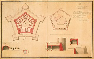
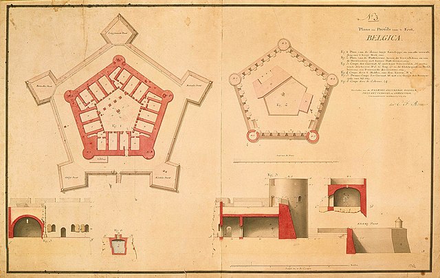
| Nederlands: Plattegrond en profiel van fort Belgica op Banda Neira
English: Map and elevation of Fort Belgica on Banda Neira Bahasa Indonesia: Peta dan elevasi Benteng Belgica di Banda Neira ( |
||||||||||||||||||||||||
|---|---|---|---|---|---|---|---|---|---|---|---|---|---|---|---|---|---|---|---|---|---|---|---|---|
| Awtur |
Nederlands: Carl Friedrich Reimer (landmeter / kaartenmaker), I.O. Vaillant (opdrachtgever), C.A. Verhuell (opdrachtgever), J.F.L van Gravestein (opdrachtgever)
English: Carl Friedrich Reimer (land surveyor / mapmaker), I.O. Vaillant (patron), C.A. Verhuell (patron), J.F.L van Gravestein (patron) |
|||||||||||||||||||||||
| Titlu |
Nederlands: Plattegrond en profiel van fort Belgica op Banda Neira
English: Map and elevation of Fort Belgica on Banda Neira
Bahasa Indonesia: Peta dan elevasi Benteng Belgica di Banda Neira |
|||||||||||||||||||||||
| Deskrizzjoni |
Nederlands: Titel catalogus Leupe (NA): Plans en profils van 't fort Belgica.
Legenda: 1-6 Genummerd: No. 3. Notities verso: 664 [met vette cijfers gestempeld op een etiketje]. 15 [Rijnlandse] roeden = 205 strepen; omgerekende schaal [1 : 275] [Plans] / 5 [Rijnlandse] roeden = 217 strepen; omgerekende schaal [1 : 86] [Coupes].English: According to the Leupe catalogue (NA), the original title reads: Plans en profils van 't fort Belgica.
Key: 1-6 Numbered: No.3. Notes on reverse: 664 [stamped in bold on a small label]. 15 [Rhenish] rods = 205 stripes; converted scale [1 : 275] [Plans] / 5 [Rhenish] rods = 217 stripes; converted scale [1 : 86] [Coupes].Bahasa Indonesia: Menurut katalog Leupe (NA), judul aslinya berbunyi: Plans en profils van 't fort Belgica.
Kunci: 1-6 Diberi nomor: No.3. Catatan di belakang: 664 [dicetak tebal pada sebuah label]. 15 [Rhenish] rods = 205 stripes; converted scale [1 : 275] [Plans] / 5 [Rhenish] rods = 217 stripes; converted scale [1 : 86] [Coupes]. |
|||||||||||||||||||||||
| Data | circa 1791 | |||||||||||||||||||||||
| Teknika |
Nederlands: ingekleurde tekening op papier
English: coloured drawing on paper
Bahasa Indonesia: gambar berwarna di atas kertas |
|||||||||||||||||||||||
| Qisien | height: 100 cm;width: 64.5 cm | |||||||||||||||||||||||
| Collection |
|
|||||||||||||||||||||||
| Numru ta' adeżjoni |
NL-HaNA_4.VEL_1362 (old number: VEL1362) |
|||||||||||||||||||||||
| Skrizzjonijiet |
N:o 3 / Plans en profils van 't fort Belgica
author: C.F. Reimer |
|||||||||||||||||||||||
| Noti |
English: Subjects: key, fortification, cross-section / profile, chart / map / plan
Nederlands: Onderwerpen: legenda, vesting, doorsnede / profiel, plattegrond / kaart
English: Fort: this image is related to a VOC fort called fort Belgica |
|||||||||||||||||||||||
| Sors/Fotografu |
|
|||||||||||||||||||||||
| Permess (Użu mill-ġdid tal-fajl) |
|
|||||||||||||||||||||||

| Object location | | View this and other nearby images on: OpenStreetMap |
|---|
Kronoloġija tal-fajl
Agħfas fuq il-grupp data/ħin biex tara l-fajl biex tara kif jidher dak il-ħin.
| Data/Ħin | Minjatura | Qisien | Utent | Kumment | |
|---|---|---|---|---|---|
| kurrenti | 17:09, 10 Ġunju 2014 | | 2,400 × 1,515 (478 KB) | HuskyBot | == {{int:filedesc}} == {{Artwork |title = {{nl|1=Plattegrond en profiel van fort Belgica op Banda Neira}} {{en|1=Map and elevation of Fort Belgica on Banda Neira}} |description = {{nl|1=Titel catalogus Leupe (N... |
Użu tal-fajl
Il-Paġna segwenti twassal għal din l-istampa:
L-użu globali tal-fajl
Il-wikis segwenti jużaw dan il-fajl:
- Użu fuq en.wikipedia.org
- Użu fuq es.wikipedia.org
- Użu fuq it.wikipedia.org