
Stampa:AMH-4720-NA The forts of Nassau and Belgica and the Neira redoubt on Banda Neira.jpg

Fajl oriġinali (2,400 × 1,905 pixel, dimensjoni: 858 KB, tip ta' MIME: image/jpeg)
| Dan huwa fajl mill-Wikimedia Commons. Il-deskrizzjoni fuq il-paġna ta' diskussjoni oriġinali tidher hawn taħt.
|
Taqsira
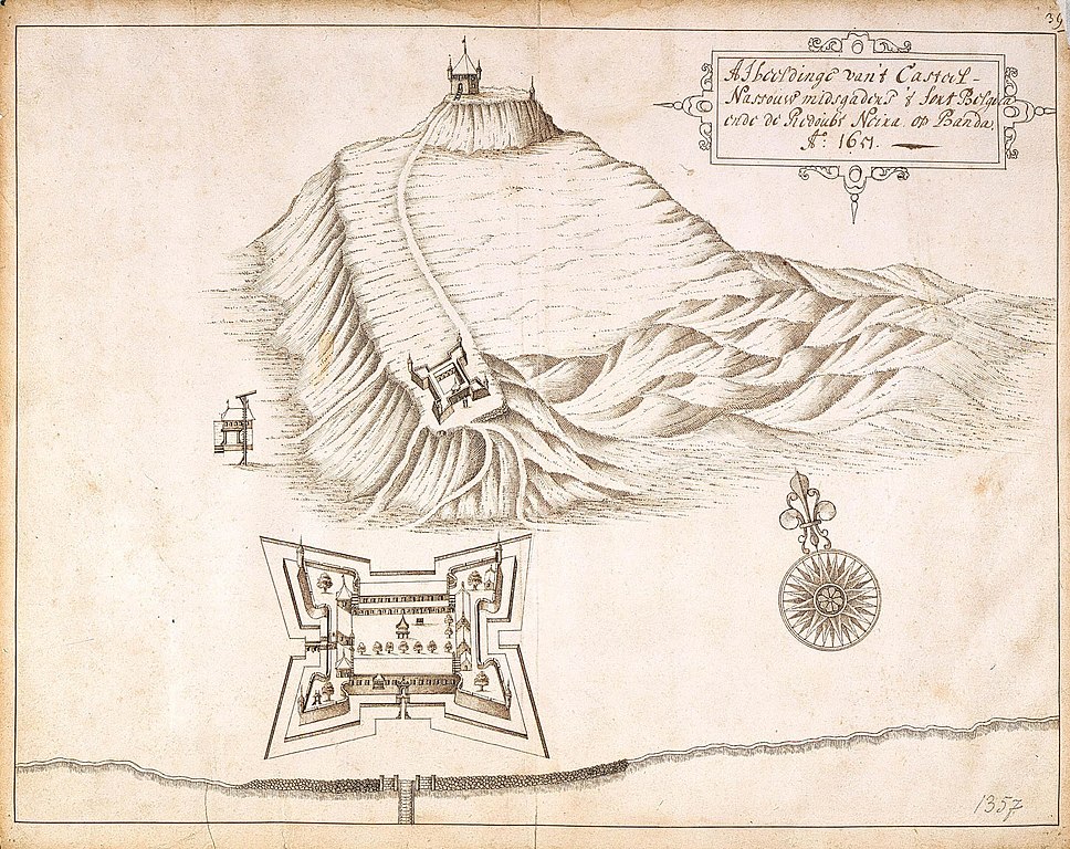
| Nederlands: Forten Nassau en Belgica en redoute Neira op Banda Neira
English: The forts of Nassau and Belgica and the Neira redoubt on Banda Neira ( |
||||||||||||||||||||||||
|---|---|---|---|---|---|---|---|---|---|---|---|---|---|---|---|---|---|---|---|---|---|---|---|---|
| Awtur |
Nederlands: Johannes (van) Nessel (toegeschreven aan landmeter/kaartenmaker)
English: Johannes (van) Nessel (assigned to land surveyor / mapmaker) |
|||||||||||||||||||||||
| Titlu |
Nederlands: Forten Nassau en Belgica en redoute Neira op Banda Neira
English: The forts of Nassau and Belgica and the Neira redoubt on Banda Neira |
|||||||||||||||||||||||
| Deskrizzjoni |
Nederlands: Titel catalogus Leupe (NA): Afbeeldinge van 't Casteel Nassauw, mitsgaders 't fort Belgica ende redoubt Neira op Banda.
Behoort bij het rapport van Arnold de Vlamingh van Outshoorn. Rechts boven genummerd: 392. De randen zijn aan de achterzijde beplakt. Notities verso: 392 [moet het folionummer in de band OBP zijn] / 664 [over de letter achter dit getal is een strook geplakt].English: According to the Leupe catalogue (NA), the original title reads: Afbeeldinge van 't Casteel Nassauw, mitsgaders 't fort Belgica ende redoubt Neira op Banda.
Belongs with the report of Arnold de Vlamingh van Outshoorn. Numbered top right: 392. The edges have been reinforced on the back. Notes on reverse: 392 [must refer to the folio number in the OBP volume]/664[the letter following the number has been obscured by a strip of paper]. |
|||||||||||||||||||||||
| Data | 1651 | |||||||||||||||||||||||
| Teknika |
Nederlands: pen op papier
English: pen on paper |
|||||||||||||||||||||||
| Qisien | height: 41.5 cm;width: 33 cm | |||||||||||||||||||||||
| Collection |
|
|||||||||||||||||||||||
| Numru ta' adeżjoni |
NL-HaNA_4.VEL_1357 (old number: VEL1357) |
|||||||||||||||||||||||
| Skrizzjonijiet |
Afbeeldinge van 't Casteel Nassauw, midsgaders 't fort Belgica ende redoubt Neira op Banda
|
|||||||||||||||||||||||
| Noti |
English: Subjects: survey / view, compass / dial, fortification, banderole / cartouche / ornamentation
Nederlands: Onderwerpen: overzicht / aanzicht, kompas / windroos, vesting, banderol / cartouche / versiering
English: Fort: this image is related to a VOC fort called fort Belgica |
|||||||||||||||||||||||
| Sors/Fotografu |
|
|||||||||||||||||||||||
| Permess (Użu mill-ġdid tal-fajl) |
|
|||||||||||||||||||||||

| Object location | | View this and other nearby images on: OpenStreetMap |
|---|
Kronoloġija tal-fajl
Agħfas fuq il-grupp data/ħin biex tara l-fajl biex tara kif jidher dak il-ħin.
| Data/Ħin | Minjatura | Qisien | Utent | Kumment | |
|---|---|---|---|---|---|
| kurrenti | 17:08, 10 Ġunju 2014 | | 2,400 × 1,905 (858 KB) | HuskyBot | == {{int:filedesc}} == {{Artwork |title = {{nl|1=Forten Nassau en Belgica en redoute Neira op Banda Neira}} {{en|1=The forts of Nassau and Belgica and the Neira redoubt on Banda Neira}} |description = {{nl|1=Ti... |
Użu tal-fajl
Il-Paġna segwenti twassal għal din l-istampa:
L-użu globali tal-fajl
Il-wikis segwenti jużaw dan il-fajl:
- Użu fuq en.wikipedia.org
- Użu fuq es.wikipedia.org
- Użu fuq fr.wikipedia.org