
Stampa:Exterior aerial plaza view, facing northwest. - Los Angeles Music Center, 135 North Grand Avenue, Los Angeles, Los Angeles County, CA HABS CA-2780-18.tif

Size of this JPG preview of this TIF file: 743 × 599 pixels. Riżoluzzjonijiet oħra: 298 × 240 pixels | 595 × 480 pixels | 952 × 768 pixels | 1,269 × 1,024 pixels | 2,539 × 2,048 pixels | 5,362 × 4,326 pixels
Fajl oriġinali (5,362 × 4,326 pixel, dimensjoni: 22.12 MB, tip ta' MIME: image/tiff)
| Dan huwa fajl mill-Wikimedia Commons. Il-deskrizzjoni fuq il-paġna ta' diskussjoni oriġinali tidher hawn taħt.
|
Taqsira
| Exterior aerial plaza view, facing northwest. - Los Angeles Music Center, 135 North Grand Avenue, Los Angeles, Los Angeles County, CA | ||||
|---|---|---|---|---|
| Fotografu |
Related names:
|
|||
| Titlu |
Exterior aerial plaza view, facing northwest. - Los Angeles Music Center, 135 North Grand Avenue, Los Angeles, Los Angeles County, CA |
|||
| Deskrizzjoni |
English: Los Angeles Music Center — Music Center Plaza with Jacques Lipchitz sculpture and fountain, with the Mark Taper Forum (top) and corner of the DWP Building (top left). * Image: HABS—Historic American Buildings Survey of Los Angeles. |
|||
| Depicted place | California; Los Angeles County; Los Angeles | |||
| Data | Documentation compiled after 1933 | |||
| Qisien | 4 x 5 in. | |||
| Post attwali |
Library of Congress Prints and Photographs Division Washington, D.C. 20540 USA http://hdl.loc.gov/loc.pnp/pp.print |
|||
| Numru ta' adeżjoni |
HABS CA-2780-18 |
|||
| Attribuzzjoni |
|
|||
| Noti |
|
|||
| Sors | https://www.loc.gov/pictures/item/ca3304.photos.206964p | |||
| Permess (Użu mill-ġdid tal-fajl) |
|
|||

| Object location | | View this and other nearby images on: OpenStreetMap |
|---|
Kronoloġija tal-fajl
Agħfas fuq il-grupp data/ħin biex tara l-fajl biex tara kif jidher dak il-ħin.
| Data/Ħin | Minjatura | Qisien | Utent | Kumment | |
|---|---|---|---|---|---|
| kurrenti | 02:33, 7 Lulju 2014 | 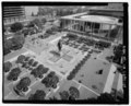 | 5,362 × 4,326 (22.12 MB) | Fæ | GWToolset: Creating mediafile for Fæ. HABS 05 July 2014 (501:600) |
Użu tal-fajl
Il-Paġna segwenti twassal għal din l-istampa:
L-użu globali tal-fajl
Il-wikis segwenti jużaw dan il-fajl:
- Użu fuq en.wikipedia.org
- Użu fuq ha.wikipedia.org
- Użu fuq sr.wikipedia.org