
Stampa:Schoenbrunn Palace precursor 1672.jpg

Daqs tad-dehra proviżorja: 800 × 564 pixels. Riżoluzzjonijiet oħra: 320 × 226 pixels | 640 × 451 pixels | 1,024 × 722 pixels | 1,280 × 902 pixels | 1,893 × 1,334 pixels
Fajl oriġinali (1,893 × 1,334 pixel, dimensjoni: 997 KB, tip ta' MIME: image/jpeg)
| Dan huwa fajl mill-Wikimedia Commons. Il-deskrizzjoni fuq il-paġna ta' diskussjoni oriġinali tidher hawn taħt.
|
| Deskrizzjoni |
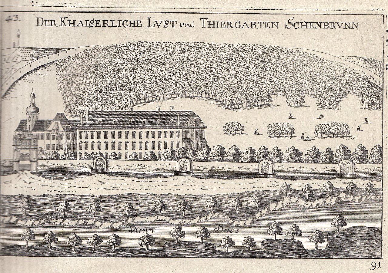
English: Copperplate engraving from "Topographia archiducatus Austriae Inferioris modernae 1672" by Georg Matthäus Vischer. Picture shows Katterburg (erected as a mansion in c. 1550) and Gonzaga palais which was commissioned by Eleonora Gonzaga and built in 1638-43. Both buildings were ruined by the Turks in 1683 and were replaced by Schönbrunn Palace, beginning in 1689.
Deutsch: Kupferstich von Georg Matthäus Vischer aus der Topographia archiducatus Austriae Inferioris modernae (1672). Er zeigt die Katterburg und das Gonzaga-Schloss (errichtet für Eleonora Gonzaga un 1640). Beide wurden im Zuge der Zweiten Türkenbelagerung 1683 zerstört und durch Schloss Schönbrunn ersetzt.
|
||||||||||||||||||||
| Data | |||||||||||||||||||||
| Sors | Topographia archiducatus Austriae Inferioris modernae 1672 | ||||||||||||||||||||
| Awtur |
|
||||||||||||||||||||

| Object location | | View this and other nearby images on: OpenStreetMap |
|---|
|
This is a faithful photographic reproduction of a two-dimensional, public domain work of art. The work of art itself is in the public domain for the following reason:
The official position taken by the Wikimedia Foundation is that "faithful reproductions of two-dimensional public domain works of art are public domain".
This photographic reproduction is therefore also considered to be in the public domain in the United States. In other jurisdictions, re-use of this content may be restricted; see Reuse of PD-Art photographs for details. | ||||
Kronoloġija tal-fajl
Agħfas fuq il-grupp data/ħin biex tara l-fajl biex tara kif jidher dak il-ħin.
| Data/Ħin | Minjatura | Qisien | Utent | Kumment | |
|---|---|---|---|---|---|
| kurrenti | 21:38, 3 Frar 2012 | | 1,893 × 1,334 (997 KB) | Feldkurat Katz | higher resolution scan |
| 21:36, 3 Frar 2012 |  | 1,893 × 1,334 (997 KB) | Feldkurat Katz | higher resolution scan | |
| 10:14, 20 Frar 2008 |  | 960 × 609 (292 KB) | W. | {{Information |Description=Drawing of Architecture; copperplate engraving, very probably from "Topographia archiducatus Austriae Inferioris modernae 1672" by de:Georg Matthäus Vischer. Picture shows ''Katterburg'' (erected as a mansion in c. 1550) |
Użu tal-fajl
Il-Paġna segwenti twassal għal din l-istampa:
L-użu globali tal-fajl
Il-wikis segwenti jużaw dan il-fajl:
- Użu fuq de.wikipedia.org
- Użu fuq de.wikivoyage.org
- Użu fuq en.wikipedia.org
- Użu fuq it.wikipedia.org
- Użu fuq ja.wikipedia.org
- Użu fuq mk.wikipedia.org
- Użu fuq pt.wikipedia.org
- Użu fuq ro.wikipedia.org
- Użu fuq simple.wikipedia.org
- Użu fuq th.wikipedia.org
- Użu fuq vi.wikipedia.org