
Stampa:1856 Kiepert Map of Lebanon - Geographicus - Lebanon-kiepert-1856.jpg

Daqs tad-dehra proviżorja: 489 × 599 pixels. Riżoluzzjonijiet oħra: 196 × 240 pixels | 392 × 480 pixels | 627 × 768 pixels | 836 × 1,024 pixels | 1,672 × 2,048 pixels | 3,000 × 3,675 pixels
Fajl oriġinali (3,000 × 3,675 pixel, dimensjoni: 2.45 MB, tip ta' MIME: image/jpeg)
| Dan huwa fajl mill-Wikimedia Commons. Il-deskrizzjoni fuq il-paġna ta' diskussjoni oriġinali tidher hawn taħt.
|
| Heinrich Kiepert: Map of Northern Palestine and Lebanon Chiefly from the Routes of E. Robinson & others.
( |
||||||||||||||||||||||||
|---|---|---|---|---|---|---|---|---|---|---|---|---|---|---|---|---|---|---|---|---|---|---|---|---|
| Artist |
|
|||||||||||||||||||||||
| Titlu |
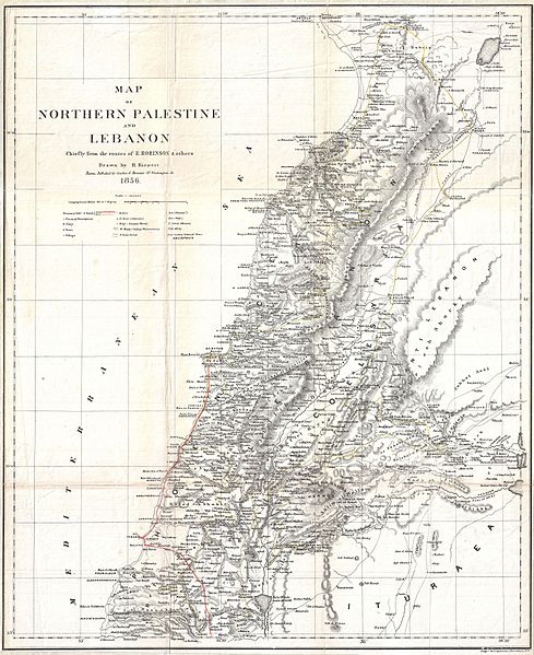
Map of Northern Palestine and Lebanon Chiefly from the Routes of E. Robinson & others. |
|||||||||||||||||||||||
| Deskrizzjoni |
English: An uncommon map of Lebanon by the classical scholar and cartographer H. Kiepert. Covers all of modern day Lebanon as well as parts of adjacent Israel, Palestine, Jordan and Syria. This map is based on the 1838 travels of E. Robinson and E. Smith in this area. Robinson and Smith, in search of unidentified Biblical sites, traveled throughout the Middle East but most particularly in modern day Israel, Palestine, Lebanon, Egypt, Jordan, and Syria. The duo used local traditions as well as established Biblical scholarship to identify a number of important sites. This map is largely the result of their research and work. Their route, shown in red, leads Israel northwards to Tyre then skirts the coast to Beiruit. Most place names are transliterations of Arabic though biblical references are included where appropriate. This map was drawn by Heinrich Kiepert, a noted expert on historical cartography, for Robinson’s important work Biblical Researches in Palestine, and in the Adjacent Regions. |
|||||||||||||||||||||||
| Data | 1856 (undated) | |||||||||||||||||||||||
| Qisien | height: 20 in (50.8 cm);width: 16.5 in (41.9 cm) | |||||||||||||||||||||||
| Numru ta' adeżjoni |
Geographicus link: Lebanon-kiepert-1856 |
|||||||||||||||||||||||
| Sors/Fotografu |
Robinson, E., and Smith, E., Biblical Researches in Palestine, and in the Adjacent Regions. A Journal of Travels in the Year 1838. (Boston: Crocker & Brewster) 1856.
|
|||||||||||||||||||||||
| Permess (Użu mill-ġdid tal-fajl) |
|
|||||||||||||||||||||||
Loescher_%26_btv1b8453164n_(cropped).jpg)
Kronoloġija tal-fajl
Agħfas fuq il-grupp data/ħin biex tara l-fajl biex tara kif jidher dak il-ħin.
| Data/Ħin | Minjatura | Qisien | Utent | Kumment | |
|---|---|---|---|---|---|
| kurrenti | 22:16, 24 Marzu 2011 | | 3,000 × 3,675 (2.45 MB) | BotMultichillT | {{subst:User:Multichill/Geographicus |link=http://www.geographicus.com/P/AntiqueMap/Lebanon-kiepert-1856 |product_name=1856 Kiepert Map of Lebanon |map_title=Map of Northern Palestine and Lebanon Chiefly from the Routes of E. Robinson & others. |descripti |
Użu tal-fajl
L-użu globali tal-fajl
Il-wikis segwenti jużaw dan il-fajl:
- Użu fuq ar.wikipedia.org
- Użu fuq en.wikipedia.org
- History of Lebanon
- Baalbek
- Lebanese Civil War
- Greater Lebanon
- Cedar Revolution
- Assassinations linked to the Cedar Revolution
- Good Fence
- Lebanese Independence Day
- History of ancient Lebanon
- Template:History of Lebanon
- 2006–2008 Lebanese protests
- Youssef Bey Karam
- Phoenicia under Assyrian rule
- Phoenicia under Babylonian rule
- List of attacks in Lebanon
- 2008 Lebanon conflict
- Wikipedia:WikiProject Lebanon/Resources
- Timeline of Lebanese history
- Wikipedia:WikiProject Lebanon/Templates
- History of Lebanon under Ottoman rule
- Phoenicia under Hellenistic rule
- Phoenicia under Roman rule
- Mount Lebanon Mutasarrifate
- List of wars involving Lebanon
- List of rivers of Lebanon
- User:༆/History of Asia templates
- Timeline of Beirut
- Harfush dynasty
- List of years in Lebanon
- Tomb of the Unknown Soldier (Lebanon)
- History of Tyre, Lebanon
- Second Lebanese Republic
- Template:History of Lebanon/doc
- History of Beirut
- Kisrawan
- 5th century in Lebanon
- 4th century in Lebanon
- 6th century in Lebanon
- 7th century in Lebanon
- 8th century in Lebanon
- 9th century in Lebanon
- 10th century in Lebanon
- 3rd century in Lebanon
- 2nd century in Lebanon
- 1st century in Lebanon
- History of Tripoli, Lebanon
- Double Qaim-Maqamate of Mount Lebanon
- User:Red Phoenician/Tur Lebnon
- Draft:History of Baalbek
Ara l-użu globali ta' dan il-fajl.