
Stampa:16-07-06-Rathaus Graz Turmblick-RR2 0275.jpg
Fajl oriġinali (4,288 × 2,848 pixel, dimensjoni: 9.76 MB, tip ta' MIME: image/jpeg)
| Dan huwa fajl mill-Wikimedia Commons. Il-deskrizzjoni fuq il-paġna ta' diskussjoni oriġinali tidher hawn taħt.
|
Taqsira
| Deskrizzjoni |
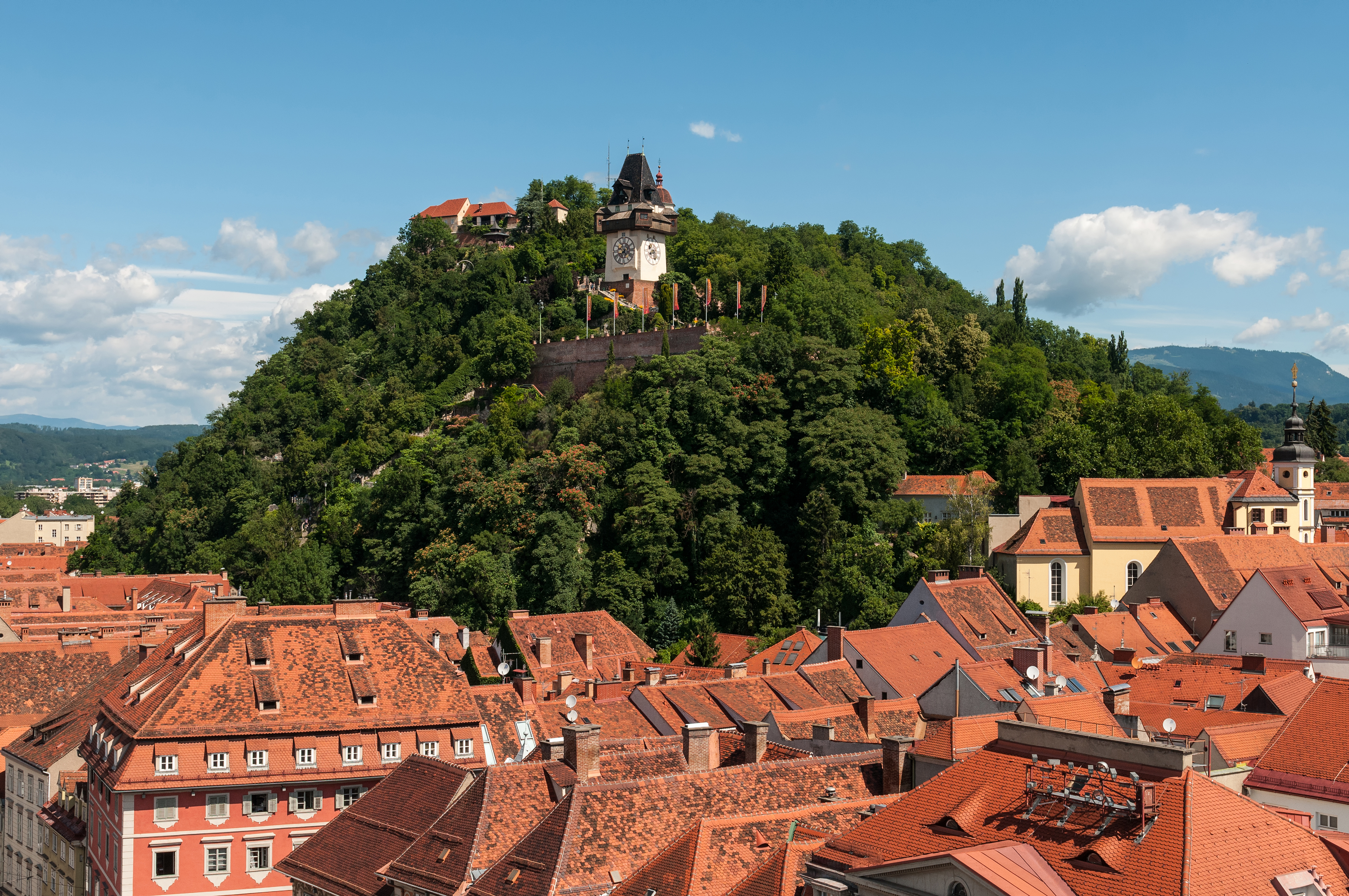
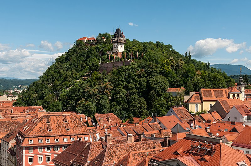
Deutsch: Schloßberg Graz, Blick von der Turmspitze des Rathauses
Čeština: Štýrský Hradec, pohled z věže radnice
Català: Castell del Pujol Graz, vista des de la torre de l'ajuntament
Español: Castillo de la Colina Graz, vista desde la torre del ayuntamiento
Русский: Шлоссберг Грац, Вид с башни ратуши
English: Castle mountain Graz, view from the spire of the town hall
|
|||||||||||||||||||||||
| Data | ||||||||||||||||||||||||
| Sors | Opra proprja | |||||||||||||||||||||||
| Awtur |
|
|||||||||||||||||||||||
| Permess (Użu mill-ġdid tal-fajl) |
|
|||||||||||||||||||||||


| Camera location | | View this and other nearby images on: OpenStreetMap |
|---|
| Object location | | View this and other nearby images on: OpenStreetMap |
|---|
Assessment
|
Din l-istampa ġiet magħżulha bħala stampa tal-ġurnata għal 6 July 2023. Id-deskrizzjoni tagħha hi: English: Castle mountain Graz, view from the spire of the town hall. Lingwi oħra:
Čeština: Mohutná skála Schloßberg nad rakouským Štýrským Hradcem (Gratzem), z jehož radniční věže byl nafotografován tento snímek. Deutsch: Der Grazer Schloßberg. English: Castle mountain Graz, view from the spire of the town hall. Español: Schloßberg, vista desde la torre del ayuntamiento. Français : Le Schloßberg, colline de Graz (Autriche) abritant un jardin public et une forteresse. Vue ici depuis la tour de l'hôtel de ville. Italiano: Vista del monte castello di Graz dalla guglia del municipio, nella città di Graz in Austria. Nederlands: Blik op de Uhrturm op de Schlossberg in Graz, de hoofdstad van de Oostenrijkse deelstaat Stiermarken Português: Montanha do castelo em Graz, Áustria, vista da torre da prefeitura. |
This image has been assessed using the Quality image guidelines and is considered a Quality image.
|
Wikipedia-Landtagsprojekt/Steiermark 20165. of July 2016 in Graz More than 10 persons participated in this project voluntarily and without expense allowance.
|
|
 |
Usage informationIf you need more information how to use this file, please send an |
|
The making of this work was supported by Wikimedia Austria. For other files made with the support of Wikimedia Austria, please see the category Supported by Wikimedia Österreich. |
The making of this document was supported by Skillshare.
To see other files made with the support of Skillshare, please see the category Supported by Skillshare. |
- Inti ħieles:
- li taqsam – li tikkopja, tiddistribwixxi u tittrażmetti din l-opra
- li timmodifika – li tadatta l-biċċa xogħol
- Taħt il-kundizzjonijiet segwenti:
- attribuzzjoni – Għandek tattribwixxi x-xogħol bil-mod speċifikat mill-awtur jew minn min ta l-l-iċenzja (imma mhux b'xi mod li jissuġġerixxi ji jappoġjaw lilek jew l-użu tax-xogħol).
- Ixxerja bl-istess mod – Jekk tbiddel, tittrasforma jew tibni fuq dan il-materjal, inti għandek bżonn taqsam il-kontribuzzjonijiet tiegħek taħt l-istess liċenzja jew waħda li taqbel ma' dik oriġinali.

Liċenzja

|
Permission is granted to copy, distribute and/or modify this document under the terms of the GNU Free Documentation License, Version 1.2 only as published by the Free Software Foundation; with no Invariant Sections, no Front-Cover Texts, and no Back-Cover Texts. A copy of the license is included in the section entitled GNU Free Documentation License. | 1.2 biss |
Kronoloġija tal-fajl
Agħfas fuq il-grupp data/ħin biex tara l-fajl biex tara kif jidher dak il-ħin.
| Data/Ħin | Minjatura | Qisien | Utent | Kumment | |
|---|---|---|---|---|---|
| kurrenti | 22:45, 8 Lulju 2016 | | 4,288 × 2,848 (9.76 MB) | Ralf Roletschek | sky denoised |
| 20:26, 8 Lulju 2016 |  | 4,288 × 2,848 (10.28 MB) | Ralf Roletschek |
Użu tal-fajl
Il-3 paġni segwenti jwasslu għal din l-istampa:
L-użu globali tal-fajl
Il-wikis segwenti jużaw dan il-fajl:
- Użu fuq am.wikipedia.org
- Użu fuq an.wikipedia.org
- Użu fuq ar.wikipedia.org
- Użu fuq arz.wikipedia.org
- Użu fuq ast.wikipedia.org
- Użu fuq av.wikipedia.org
- Użu fuq az.wikipedia.org
- Użu fuq ban.wikipedia.org
- Użu fuq ba.wikipedia.org
- Użu fuq be-tarask.wikipedia.org
- Użu fuq bg.wikipedia.org
- Użu fuq bn.wikipedia.org
- Użu fuq ca.wikipedia.org
- Użu fuq ceb.wikipedia.org
- Użu fuq ce.wikipedia.org
- Użu fuq cs.wikipedia.org
- Użu fuq cv.wikipedia.org
- Użu fuq cy.wikipedia.org
- Użu fuq de.wikipedia.org
- Österreich
- Belagerung von Graz
- Wikipedia:Landtagsprojekt/Steiermark/Locations
- Wikipedia Diskussion:Hauptseite/Artikel des Tages/Archiv/Vorschläge/2018/Q1
- Wikipedia:Hauptseite/Archiv/13. März 2018
- Portal:Österreich/RegiowikiAT Redundanzen
- Benutzerin:Alfonsina2019
- Liste der denkmalgeschützten Objekte in Graz/Innere Stadt/O–Z
- Wikipedia:WikiProjekt Österreich/checks/Denkmalschutz/WP - WD diffs 02
- Użu fuq de.wikiversity.org
- Użu fuq de.wikivoyage.org
- Użu fuq de.wiktionary.org
- Użu fuq el.wikipedia.org
- Użu fuq en.wikipedia.org
- Użu fuq en.wikivoyage.org
- Użu fuq eo.wikipedia.org
- Użu fuq eo.wikivoyage.org
- Użu fuq eu.wikipedia.org
- Użu fuq fa.wikipedia.org
- Użu fuq fi.wikipedia.org
Ara l-użu globali ta' dan il-fajl.