
Stampa:Uluru from above Iss049e010638 lrg.jpg

Daqs tad-dehra proviżorja: 800 × 532 pixels. Riżoluzzjonijiet oħra: 320 × 213 pixels | 640 × 426 pixels | 1,024 × 682 pixels | 1,280 × 852 pixels | 2,560 × 1,704 pixels | 4,928 × 3,280 pixels
Fajl oriġinali (4,928 × 3,280 pixel, dimensjoni: 4.83 MB, tip ta' MIME: image/jpeg)
| Dan huwa fajl mill-Wikimedia Commons. Il-deskrizzjoni fuq il-paġna ta' diskussjoni oriġinali tidher hawn taħt.
|
Taqsira
| Deskrizzjoni |
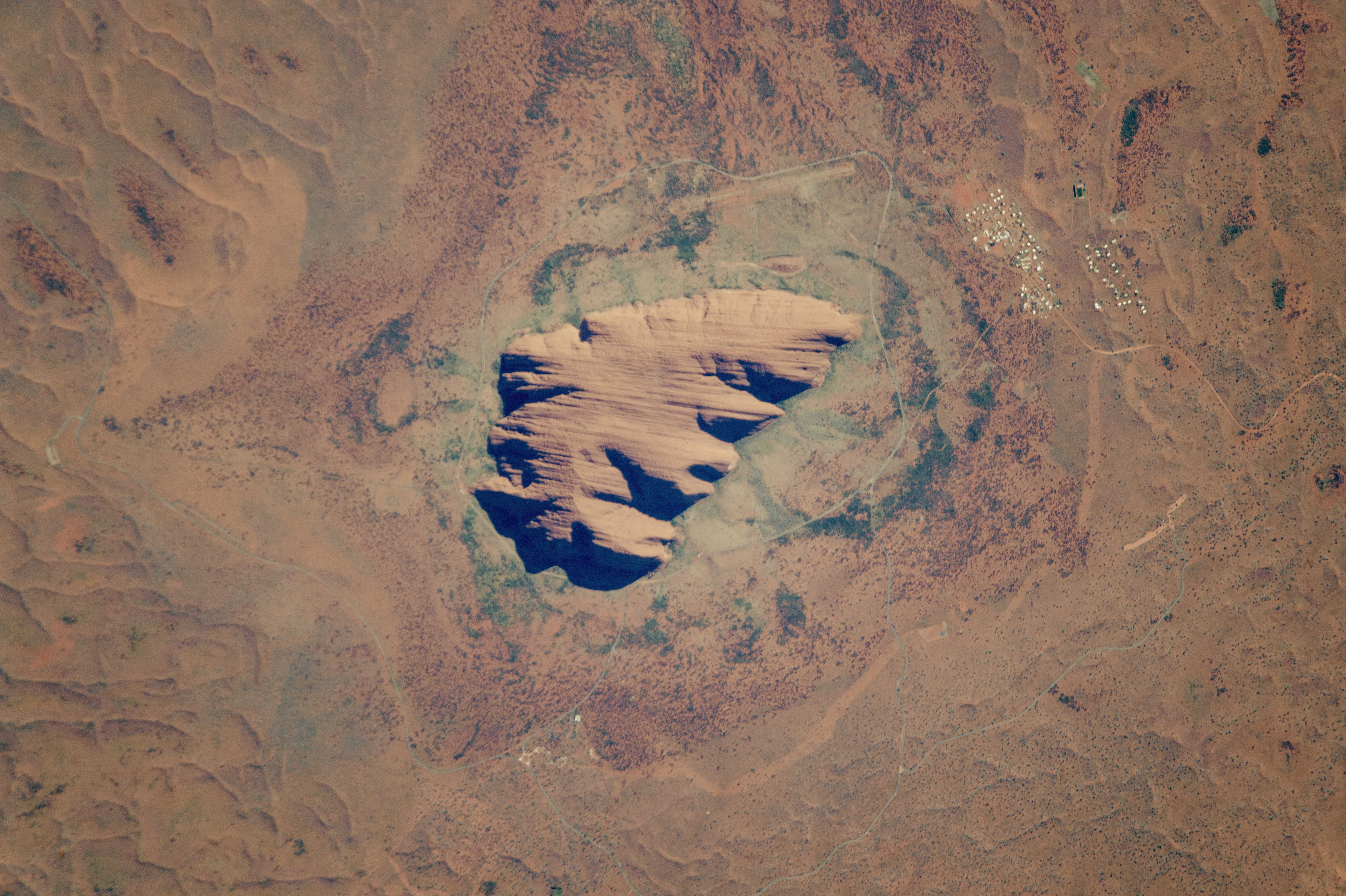
English: Astronaut photograph ISS049-E-10638 was acquired on September 23, 2016, with a Nikon D4 digital camera using a 1600 millimeter lens, and is provided by the ISS Crew Earth Observations Facility and the Earth Science and Remote Sensing Unit, Johnson Space Center. The image was taken by a member of the Expedition 49 crew. The image has been cropped and enhanced to improve contrast, and lens artifacts have been removed. The International Space Station Program supports the laboratory as part of the ISS National Lab to help astronauts take pictures of Earth that will be of the greatest value to scientists and the public, and to make those images freely available on the Internet. Additional images taken by astronauts and cosmonauts can be viewed at the NASA/JSC Gateway to Astronaut Photography of Earth. Caption by by Andi Hollier, Hx5 LLC, and M. Justin Wilkinson, Texas State University, Jacobs Contract at NASA-JSC.
|
| Data | Taken on 23 Settembru 2016, 23:29:37 UTC |
| Sors | https://eoimages.gsfc.nasa.gov/images/imagerecords/89000/89288/iss049e010638_lrg.jpg |
| Awtur | NASA/JSC Gateway to Astronaut Photography of Earth / Caption by Andi Hollier, Hx5 LLC, and M. Justin Wilkinson, Texas State University, Jacobs Contract at NASA-JSC |
This image or video was catalogued by Johnson Space Center of the United States National Aeronautics and Space Administration (NASA) under Photo ID: ISS049-E-10638. This tag does not indicate the copyright status of the attached work. A normal copyright tag is still required. See Commons:Licensing. Other languages:
|
Liċenzja
This file is in the public domain in the United States because it was created by the Image Science & Analysis Laboratory, of the NASA Johnson Space Center. NASA copyright policy states that "NASA material is not protected by copyright unless noted". (NASA media use guidelines or Conditions of Use of Astronaut Photographs).
Photo source: ISS049-E-10638.
|
Kronoloġija tal-fajl
Agħfas fuq il-grupp data/ħin biex tara l-fajl biex tara kif jidher dak il-ħin.
| Data/Ħin | Minjatura | Qisien | Utent | Kumment | |
|---|---|---|---|---|---|
| kurrenti | 12:44, 10 Marzu 2021 | | 4,928 × 3,280 (4.83 MB) | Pbsouthwood | Uploaded a work by Astronaut photograph ISS049-E-10638 was acquired on September 23, 2016, with a Nikon D4 digital camera using a 1600 millimeter lens, and is provided by the ISS Crew Earth Observations Facility and the Earth Science and Remote Sensing Unit, Johnson Space Center. The image was taken by a member of the Expedition 49 crew. The image has been cropped and enhanced to improve contrast, and lens artifacts have been removed. The International Space Station Program supports the labor... |
Użu tal-fajl
Il-Paġna segwenti twassal għal din l-istampa:
L-użu globali tal-fajl
Il-wikis segwenti jużaw dan il-fajl:
- Użu fuq en.wikipedia.org