
Stampa:Parishes of Montserrat.svg

Size of this PNG preview of this SVG file: 264 × 401 pixels. Riżoluzzjonijiet oħra: 158 × 240 pixels | 316 × 480 pixels | 505 × 768 pixels | 674 × 1,024 pixels | 1,348 × 2,048 pixels
Fajl oriġinali (Fajl fil-format SVG, dimensjoni nominali 264 × 401 pixel, dimensjoni tal-fajl: 7 KB)
| Dan huwa fajl mill-Wikimedia Commons. Il-deskrizzjoni fuq il-paġna ta' diskussjoni oriġinali tidher hawn taħt.
|
Taqsira
| Deskrizzjoni |
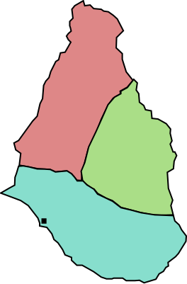
English: A map of the three parishes of the island of Montserrat. Saint Peter is shown in pale red, Saint Georges in green and Saint Anthony in blue. The black square marks Plymouth, the island's capital. Based on http://www.statoids.com/mms.html, however, map data is not detailed enough to have copyright implications. |
| Data | |
| Sors | Opra proprja |
| Awtur | Jarry1250 |
| Verżjonijiet oħra | Derivative works of this file: Montserrat location map.svg |
| SVG genesis |
Liċenzja
| I, the copyright holder of this work, release this work into the public domain. This applies worldwide. In some countries this may not be legally possible; if so: I grant anyone the right to use this work for any purpose, without any conditions, unless such conditions are required by law. |
Kronoloġija tal-fajl
Agħfas fuq il-grupp data/ħin biex tara l-fajl biex tara kif jidher dak il-ħin.
| Data/Ħin | Minjatura | Qisien | Utent | Kumment | |
|---|---|---|---|---|---|
| kurrenti | 19:42, 26 Ottubru 2009 | | 264 × 401 (7 KB) | Jarry1250 | {{Information |Description={{en|1=A map of the three parishes of the island of w:Montserrat. Saint Peter is shown in pale red, Saint Georges in green and Saint Anthony in blue. The black square marks Plymouth, the island's |
Użu tal-fajl
Il-Paġna segwenti twassal għal din l-istampa:
L-użu globali tal-fajl
Il-wikis segwenti jużaw dan il-fajl:
- Użu fuq ar.wikipedia.org
- Użu fuq ba.wikipedia.org
- Użu fuq de.wikipedia.org
- Użu fuq en.wikipedia.org
- Użu fuq es.wikipedia.org
- Użu fuq fr.wikipedia.org
- Użu fuq id.wikipedia.org
- Użu fuq is.wikipedia.org
- Użu fuq ja.wikipedia.org
- Użu fuq kk.wikipedia.org
- Użu fuq lt.wikipedia.org
- Użu fuq ml.wikipedia.org
- Użu fuq nl.wikipedia.org
- Użu fuq ru.wikipedia.org
- Użu fuq uk.wikipedia.org
- Użu fuq vi.wikipedia.org
- Użu fuq zh.wikipedia.org