
Stampa:Curaçao1836.png
Daqs tad-dehra proviżorja: 722 × 599 pixels. Riżoluzzjonijiet oħra: 289 × 240 pixels | 578 × 480 pixels | 925 × 768 pixels | 1,234 × 1,024 pixels | 2,366 × 1,964 pixels
Fajl oriġinali (2,366 × 1,964 pixel, dimensjoni: 8.15 MB, tip ta' MIME: image/png)
| Dan huwa fajl mill-Wikimedia Commons. Il-deskrizzjoni fuq il-paġna ta' diskussjoni oriġinali tidher hawn taħt.
|
Taqsira
| Deskrizzjoni |
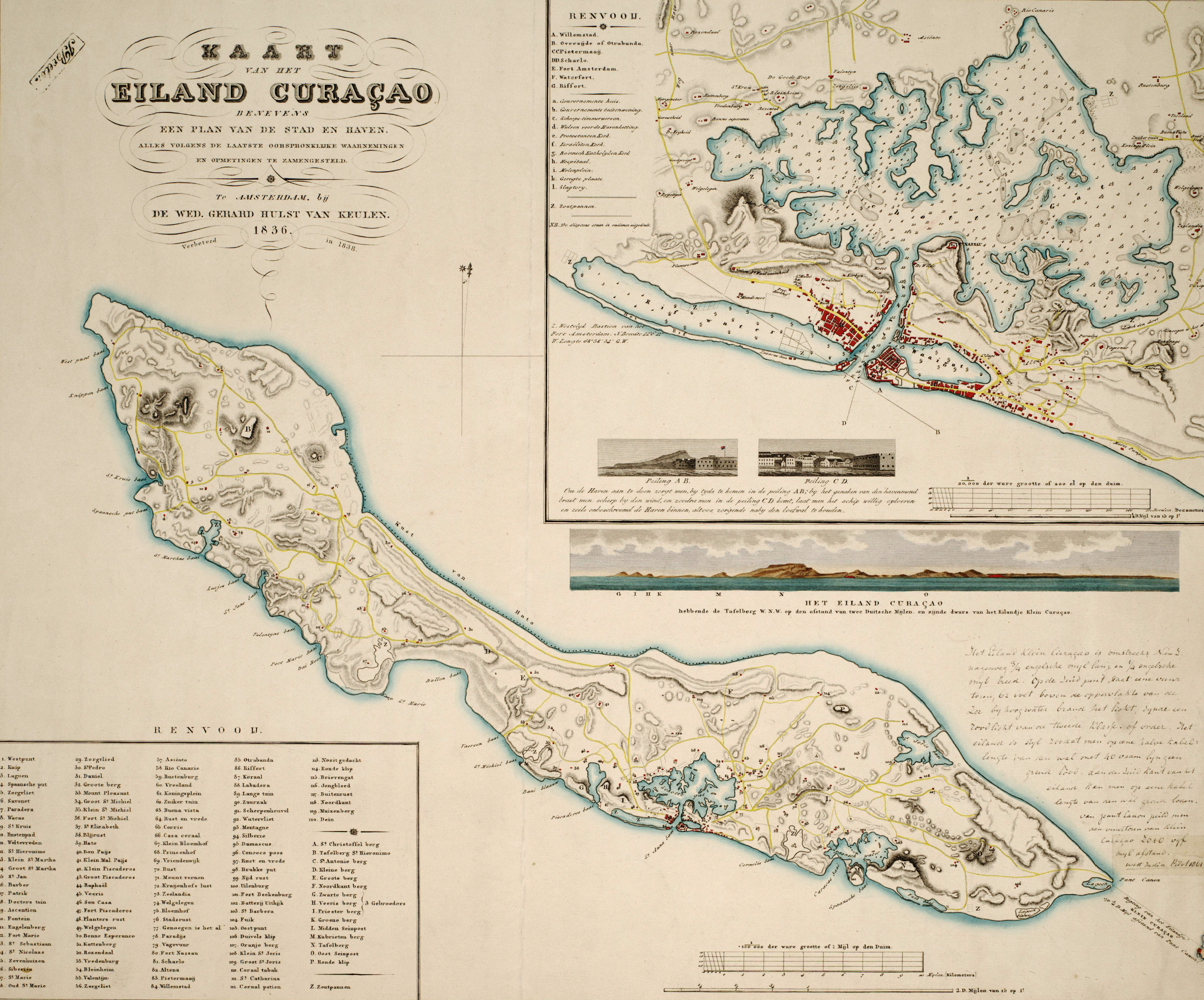
Kaart van het eiland Curaçao : benevens een plan van de stad en haven / alles volgens de laatste oorspronklijke waarnemingen en opmetingen te zamengesteld, 1836 ; verbeterd in 1838; naar de teekening van R.F. van Raders ; gegraveerd door Dl. Veelwaard Junior, Te Amsterdam : by de Wed. Gerard Hulst van Keulen, 1838 Nederlands: Kaart van Curaçao in 1836. English: Map of Curaçao in 1836. |
| Data | 1836, 1838 |
| Sors | University of Amsterdam Library |
| Awtur | R.F./van Raders, Daniël Veelwaard jr. (II) |
Liċenzja
|
This is a faithful photographic reproduction of a two-dimensional, public domain work of art. The work of art itself is in the public domain for the following reason:
The official position taken by the Wikimedia Foundation is that "faithful reproductions of two-dimensional public domain works of art are public domain".
This photographic reproduction is therefore also considered to be in the public domain in the United States. In other jurisdictions, re-use of this content may be restricted; see Reuse of PD-Art photographs for details. | ||||
Kronoloġija tal-fajl
Agħfas fuq il-grupp data/ħin biex tara l-fajl biex tara kif jidher dak il-ħin.
| Data/Ħin | Minjatura | Qisien | Utent | Kumment | |
|---|---|---|---|---|---|
| kurrenti | 12:21, 31 Diċembru 2010 | | 2,366 × 1,964 (8.15 MB) | Sreejithk2000 | Removed border |
| 17:02, 27 Mejju 2009 |  | 2,770 × 2,499 (8.45 MB) | Fentener van Vlissingen | {{Information |Description=Kaart van het eiland Curaçao : benevens een plan van de stad en haven / alles volgens de laatste oorspronklijke waarnemingen en opmetingen te zamengesteld, 1836 ; verbeterd in 1838; naar de teekening van R.F. van Raders ; gegra |
Użu tal-fajl
Il-Paġna segwenti twassal għal din l-istampa:
L-użu globali tal-fajl
Il-wikis segwenti jużaw dan il-fajl:
- Użu fuq ba.wikipedia.org
- Użu fuq en.wikipedia.org
- Użu fuq es.wikipedia.org
- Użu fuq fo.wikipedia.org
- Użu fuq ha.wikipedia.org
- Użu fuq hi.wikipedia.org
- Użu fuq id.wikipedia.org
- Użu fuq nds-nl.wikipedia.org
- Użu fuq nl.wikipedia.org
- Użu fuq no.wikipedia.org
- Użu fuq pt.wikipedia.org
- Użu fuq ru.wikipedia.org
- Użu fuq sl.wikipedia.org
- Użu fuq uk.wikipedia.org
- Użu fuq vi.wikipedia.org