
Stampa:Baro river Gambela.jpg

Mhux disponibli verżjonijiet b'risoluzzjoni akbar.
Baro_river_Gambela.jpg (500 × 500 pixel, dimensjoni: 61 KB, tip ta' MIME: image/jpeg)
| Dan huwa fajl mill-Wikimedia Commons. Il-deskrizzjoni fuq il-paġna ta' diskussjoni oriġinali tidher hawn taħt.
|
Taqsira
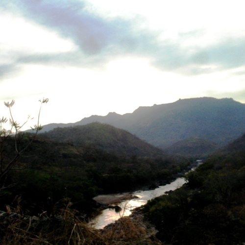
| Deskrizzjoni |
Baro River in Gambella region, Ethiopia. Original description by uploader: "taking pictures of bridges is strictly forbidden" [][?] Baro River flows to Sudan (cf. this picture). It is also the heart of the Gambella region and Gambella city. People use to go to the river to wash, refresh, chat or just take some time. People belong to many different groups: indigenous Nuer, Anuak, Majangir... or settled Highlanders (for the Abyssinian highlands regardless Amhara, Tigray or Oromo) or Sudanese refugees. The situation of demographic, ethnic and cultural diversity leads to situations of complexity. Inducing tensions, conflicts or violences. At least it is what is written in the books... So far, it looks like a paradise. |
| Data | |
| Sors | [1] |
| Awtur | T U R K A I R O |
| Camera location | | View this and other nearby images on: OpenStreetMap |
|---|
Liċenzja
Dan il-fajl huwa liċenzjat taħt it-termini tal-liċenzja Creative Commons Attribuzzjoni 2.0 Ġeneriku
- Inti ħieles:
- li taqsam – li tikkopja, tiddistribwixxi u tittrażmetti din l-opra
- li timmodifika – li tadatta l-biċċa xogħol
- Taħt il-kundizzjonijiet segwenti:
- attribuzzjoni – Għandek tattribwixxi x-xogħol bil-mod speċifikat mill-awtur jew minn min ta l-l-iċenzja (imma mhux b'xi mod li jissuġġerixxi ji jappoġjaw lilek jew l-użu tax-xogħol).
| This image was originally posted to Flickr by T U R K A I R O at https://www.flickr.com/photos/7838055@N05/2459587146. It was reviewed on 26 April 2009 by FlickreviewR and was confirmed to be licensed under the terms of the cc-by-2.0. |
Kronoloġija tal-fajl
Agħfas fuq il-grupp data/ħin biex tara l-fajl biex tara kif jidher dak il-ħin.
| Data/Ħin | Minjatura | Qisien | Utent | Kumment | |
|---|---|---|---|---|---|
| kurrenti | 12:16, 26 April 2009 | | 500 × 500 (61 KB) | Béka~commonswiki | {{Information |Description=Baro River in Gambella region, Ethiopia. Original description by uploader: [http://loc.alize.us/#/flickr:2459587146 "taking pictures of bridges is strictly forbidden"] [][?] [http://bighugelabs.com/flickr/onblack.php?id=245958 |
Użu tal-fajl
Il-Paġna segwenti twassal għal din l-istampa:
L-użu globali tal-fajl
Il-wikis segwenti jużaw dan il-fajl:
- Użu fuq af.wikipedia.org
- Użu fuq ar.wikipedia.org
- Użu fuq arz.wikipedia.org
- Użu fuq br.wikipedia.org
- Użu fuq ca.wikipedia.org
- Użu fuq ceb.wikipedia.org
- Użu fuq cs.wikipedia.org
- Użu fuq da.wikipedia.org
- Użu fuq de.wikipedia.org
- Użu fuq de.wikivoyage.org
- Użu fuq el.wikipedia.org
- Użu fuq en.wikipedia.org
- Użu fuq en.wikivoyage.org
- Użu fuq eo.wikipedia.org
- Użu fuq es.wikipedia.org
- Użu fuq fa.wikipedia.org
- Użu fuq fi.wikipedia.org
- Użu fuq fr.wikipedia.org
- Użu fuq fr.wikivoyage.org
- Użu fuq gl.wikipedia.org
- Użu fuq ha.wikipedia.org
- Użu fuq he.wikipedia.org
- Użu fuq hi.wikipedia.org
- Użu fuq hr.wikipedia.org
- Użu fuq ig.wikipedia.org
- Użu fuq it.wikipedia.org
- Użu fuq it.wikivoyage.org
- Użu fuq ja.wikipedia.org
- Użu fuq ka.wikipedia.org
- Użu fuq ko.wikipedia.org
- Użu fuq no.wikipedia.org
Ara l-użu globali ta' dan il-fajl.