
Stampa:20140720 122639 Schloss Burgsteinfurt, Steinfurt (DSC04864 crop).jpg

Fajl oriġinali (3,130 × 2,348 pixel, dimensjoni: 9.27 MB, tip ta' MIME: image/jpeg)
| Dan huwa fajl mill-Wikimedia Commons. Il-deskrizzjoni fuq il-paġna ta' diskussjoni oriġinali tidher hawn taħt.
|
.jpg)
Taqsira
| Deskrizzjoni |
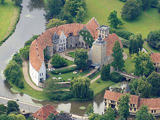
Deutsch: Schloss Burgsteinfurt, am Rande des Steinfurter Ortsteils Burgsteinfurt gelegen, ist eine der schönsten Wasserburgen des Münsterlandes. Ober- und Unterburg wurden auf zwei ovalen Inseln in der Niederung der Steinfurter Aa errichtet. Die auf Anfänge im 12. Jahrhundert zurückgehende Anlage gilt als älteste ihrer Art in Westfalen. Sie befindet sich im Eigentum der Familie zu Bentheim und Steinfurt und wird als Wohnresidenz genutzt.
Das Bild entstand während des Münsterland-Fotoflugs am 20. Juli 2014. English: Schloss Burgsteinfurt is a castle in Steinfurt, district of Steinfurt in North Rhine-Westphalia, Germany. |
| Data | |
| Sors | Photo taken by Watzmann |
| Awtur | Günter Seggebäing, Coesfeld |
| Camera location | | View this and other nearby images on: OpenStreetMap |
|---|
.jpg¶ms=052.158608_N_0007.340601_E_globe:Earth_type:camera__&language=mt)
Liċenzja
- Inti ħieles:
- li taqsam – li tikkopja, tiddistribwixxi u tittrażmetti din l-opra
- li timmodifika – li tadatta l-biċċa xogħol
- Taħt il-kundizzjonijiet segwenti:
- attribuzzjoni – Għandek tattribwixxi x-xogħol bil-mod speċifikat mill-awtur jew minn min ta l-l-iċenzja (imma mhux b'xi mod li jissuġġerixxi ji jappoġjaw lilek jew l-użu tax-xogħol).
- Ixxerja bl-istess mod – Jekk tbiddel, tittrasforma jew tibni fuq dan il-materjal, inti għandek bżonn taqsam il-kontribuzzjonijiet tiegħek taħt l-istess liċenzja jew waħda li taqbel ma' dik oriġinali.
I have published this image (this file) as author under the Creative-Commons-License CC BY-SA 3.0 (“Attribution-ShareAlike 3.0”). Legally binding is only the full legalcode.
This means that free usage outside of Wikimedia projects is possible under the following terms of license:
- The image is credited with “© Günter Seggebäing, CC BY-SA 3.0” as part of the caption, of the image credits or of the edition notice. Provide a copy of, or the URI for, the applicable license (https://creativecommons.org/licenses/by-sa/3.0/legalcode).
- If this is not possible (due to shortage of space), contact me first.
- In online presences the author is mentioned, and weblinks to the original image and to the licence model are set: “© Günter Seggebäing, Wikimedia Commons, CC BY-SA 3.0”
.jpg)
Any of the above conditions can be waived if you get permission from the copyright holder.
This license and the rights granted hereunder will terminate automatically upon any breach by you of the terms of this license. In this case the author reserves to demand declaration to cease and desist, and compensation (according to the MFM fee references currently in force).
I would be happy to receive a specimen copy or the URL of the website where the image is used.
Please contact me (eMail via Wikipedia), if you
- need my postal address for sending a specimen copy or
- have further questions to the terms of license or
- like to have the picture in higher resolution or
- need another license model for usage.
⇒ More informations about reusing content from Wikimedia Commons.
|
The license of this work is not consistent with the licensing terms of Facebook. Therfore it is not permitted to use this work on Facebook |
| Dieses Foto entstand aufgrund eines Projektes, das von Wikimedia Deutschland e. V. gefördert wurde.
Im Rahmen des „Community-Projektbudgets“ sollen Luftbilder u. a. vom Münsterland angefertigt werden. Das Projekt „Fotoflüge“ wurde im September 2011 begonnen. Ziel dieses Fotoflugs war das westliche Münsterland. Flüge des Projekts im Münsterland: 12. April 2014 · 1. Juni 2014 · 7. Juni 2014 · 20. Juli 2014 · 1. November 2014 |
Kronoloġija tal-fajl
Agħfas fuq il-grupp data/ħin biex tara l-fajl biex tara kif jidher dak il-ħin.
| Data/Ħin | Minjatura | Qisien | Utent | Kumment | |
|---|---|---|---|---|---|
| kurrenti | 09:56, 30 Awwissu 2014 | | 3,130 × 2,348 (9.27 MB) | Watzmann |
Użu tal-fajl
Il-Paġna segwenti twassal għal din l-istampa:
L-użu globali tal-fajl
Il-wikis segwenti jużaw dan il-fajl:
- Użu fuq bg.wikipedia.org
- Арнолд I фон Бентхайм-Щайнфурт
- Балдуин III фон Щайнфурт
- Лудвиг фон Бентхайм-Щайнфурт
- Алексий фон Бентхайм-Щайнфурт
- Балдуин II фон Щайнфурт
- Лудолф I фон Щайнфурт
- Рудолф II фон Щайнфурт
- Лудолф II фон Щайнфурт
- Лудолф VI фон Щайнфурт
- Лудолф VII фон Щайнфурт
- Юлиана Вилхелмина фон Шлезвиг-Холщайн-Зондербург-Глюксбург
- Лудолф IV фон Щайнфурт
- Паулина фон Валдек-Пирмонт
- Лудвиг фон Бентхайм-Щайнфурт (1812–1890)
- Алексис фон Бентхайм-Щайнфурт
- Виктор Адолф фон Бентхайм-Щайнфурт
- Ебервин I фон Бентхайм
- Вилхелмина фон Золмс-Браунфелс
- Фридрих фон Бентхайм-Щайнфурт
- Фердинанд фон Бентхайм-Щайнфурт
- Użu fuq de.wikipedia.org
- Użu fuq en.wikipedia.org
- Użu fuq fr.wikipedia.org
- Użu fuq fy.wikipedia.org
- Użu fuq sl.wikipedia.org
.jpg)