
Stampa:Kingdom of Asturias 814.svg

Size of this PNG preview of this SVG file: 500 × 380 pixels. Riżoluzzjonijiet oħra: 316 × 240 pixels | 632 × 480 pixels | 1,011 × 768 pixels | 1,280 × 973 pixels | 2,560 × 1,946 pixels
Fajl oriġinali (Fajl fil-format SVG, dimensjoni nominali 500 × 380 pixel, dimensjoni tal-fajl: 751 KB)
| Dan huwa fajl mill-Wikimedia Commons. Il-deskrizzjoni fuq il-paġna ta' diskussjoni oriġinali tidher hawn taħt.
|
Taqsira


.svg)
.svg)
.svg)
.svg)
.svg)


.svg)
.svg)
.svg)


.png)
.png)


.svg)


.svg)

.svg)


.svg)
.svg)
.svg)
.svg)


.svg)
.png)


.svg)


.svg)
.svg)


.svg)


.svg)


.png)
.svg)
.svg)
.svg)
.svg)
.svg)
.svg)
.svg)
_cropped.svg)
.svg)
.svg)
.svg)
.svg)
.svg)
.svg)
.svg)
.svg)
.svg)
.svg)
.svg)
.svg)
.svg)
.svg)
.svg)
.svg)
.svg)
.svg)
.svg)
.svg)
.svg)
.svg)
.svg)
.svg)
.svg)
.svg)
.svg)
.svg)
.svg)
.svg)
.svg)
.svg)
.svg)
.svg)
.svg)
.svg)
.svg)
.svg)
.svg)
.svg)
.svg)
.svg)
.svg)
.svg)
.svg)
Liċenzja
This file is licensed under the Creative Commons Attribution-Share Alike 4.0 International license.
- Inti ħieles:
- li taqsam – li tikkopja, tiddistribwixxi u tittrażmetti din l-opra
- li timmodifika – li tadatta l-biċċa xogħol
- Taħt il-kundizzjonijiet segwenti:
- attribuzzjoni – Għandek tattribwixxi x-xogħol bil-mod speċifikat mill-awtur jew minn min ta l-l-iċenzja (imma mhux b'xi mod li jissuġġerixxi ji jappoġjaw lilek jew l-użu tax-xogħol).
- Ixxerja bl-istess mod – Jekk tbiddel, tittrasforma jew tibni fuq dan il-materjal, inti għandek bżonn taqsam il-kontribuzzjonijiet tiegħek taħt l-istess liċenzja jew waħda li taqbel ma' dik oriġinali.
Kronoloġija tal-fajl
Agħfas fuq il-grupp data/ħin biex tara l-fajl biex tara kif jidher dak il-ħin.
| Data/Ħin | Minjatura | Qisien | Utent | Kumment | |
|---|---|---|---|---|---|
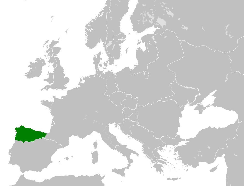
| kurrenti | 18:07, 25 Mejju 2016 | | 500 × 380 (751 KB) | Alphathon | == {{int:filedesc}} == {{Inkscape}} {{Information |Description={{en|A map of the en:Kingdom of Asturias within Europe circa 814 CE.}} |Source= {{Derived from|Blank_map_of_Europe.svg|display=50}} '''Data source:''' http://www.lib.utexas.edu/... |
Użu tal-fajl
Il-Paġna segwenti twassal għal din l-istampa:
L-użu globali tal-fajl
Il-wikis segwenti jużaw dan il-fajl:
- Użu fuq ar.wikipedia.org
- Użu fuq azb.wikipedia.org
- Użu fuq cs.wikipedia.org
- Użu fuq da.wikipedia.org
- Użu fuq en.wikipedia.org
- Użu fuq es.wikipedia.org
- Użu fuq fi.wikipedia.org
- Użu fuq he.wikipedia.org
- Użu fuq id.wikipedia.org
- Użu fuq it.wikipedia.org
- Użu fuq ja.wikipedia.org
- Użu fuq ko.wikipedia.org
- Użu fuq lfn.wikipedia.org
- Użu fuq lv.wikipedia.org
- Użu fuq pl.wikipedia.org
- Użu fuq pt.wikipedia.org
- Użu fuq ru.wikipedia.org
- Użu fuq simple.wikipedia.org
- Użu fuq th.wikipedia.org
- Użu fuq uk.wikipedia.org
- Użu fuq vi.wikipedia.org
- Użu fuq xmf.wikipedia.org
.png)